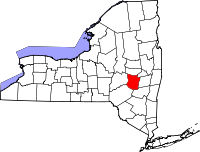
Schoharie County, New York
| Schoharie County, New York | ||
|---|---|---|

Schoharie County Courthouse
|
||
|
||
 Location in the U.S. state of New York |
||
 New York's location in the U.S. |
||
| Founded | 1795 | |
| Seat | Schoharie | |
| Largest town | Cobleskill | |
| Area | ||
| • Total | 626 sq mi (1,621 km2) | |
| • Land | 622 sq mi (1,611 km2) | |
| • Water | 4.5 sq mi (12 km2), 0.7% | |
| Population | ||
| • (2010) | 32,749 | |
| • Density | 53/sq mi (20/km²) | |
| Congressional district | 19th | |
| Time zone | Eastern: UTC-5/-4 | |
| Website | www |
|
Schoharie County is a county located in the U.S. state of New York. As of the 2010 census, the population was 32,749, making it the fifth-least populous county in New York. The county seat is Schoharie. The name of the county and the county seat come from a Mohawk word meaning "floating driftwood."
Schoharie County is part of the Albany-Schenectady-Troy, NY Metropolitan Statistical Area.
The large territory of the county (much of upstate and western New York) was long occupied by the Mohawk Indians and, to the west, other four tribes of the Iroquois League (increased to six with the migration of the Tuscarora from the South to New York in 1722). After European colonization of the Northeast started, the Mohawk had a lucrative fur trade with the French coming down from Canada, as well as the early Dutch colonists, and later British and German colonists.
Some Palatine Germans, who worked in camps on the Hudson to pay off their passage in 1710, later settled in this county in the 1720s and 30s. In addition, Scots-Irish immigrants settled in the present Schoharie County area before the American Revolutionary War, especially near Cherry Creek.
After Great Britain defeated the Dutch and took over their colony in 1664, they began to establish counties in the New York territory in 1683. The present Schoharie County was first part of Albany County. This was an enormous county, including the northern part of New York State as well as all of the present State of Vermont. In theory, it extended westward to the Pacific Ocean, as the colonists wanted to keep their options open. This county was reduced in size on July 3, 1766 by the creation of Cumberland County, and further on March 16, 1770 by the creation of Gloucester County, both containing territory now part of Vermont.
...
Wikipedia

