Siaogang District
|
Xiaogang 小港區 |
|
|---|---|
| District | |
| Xiaogang District | |
 |
|
| Nickname(s): Port Edge 港仔墘 (pinyin: Gǎngzaǐqián) |
|
 |
|
| Coordinates: 22°33′16″N 120°21′37″E / 22.554416°N 120.360176°ECoordinates: 22°33′16″N 120°21′37″E / 22.554416°N 120.360176°E | |
| Country | Taiwan |
| Region | Southern Taiwan |
| City | Kaohsiung City |
| Subdivisions |
List
|
| Area | |
| • Total | 45.4426 km2 (17.5455 sq mi) |
| Population (January 2016) | |
| • Total | 156,220 |
| • Density | 3,400/km2 (8,900/sq mi) |
| Website | Official website |
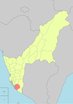
Xiaogang District (Chinese: 小港區; pinyin: Xiǎogāng Qū; Wade–Giles: Hsiao3-kang1 Ch'ü1; Pe̍h-ōe-jī: Sió-káng-khu) is the southernmost district of Kaohsiung City in southern Taiwan. The second largest airport in Taiwan, Kaohsiung International Airport, is located here.
Xiaogang was developed during Dutch era. The Dutch built Ang mo Harbor as an addition to Anping Harbor in Tainan. After losing the war against Koxinga, the Dutch left Taiwan. Koxinga's government developed Taiwan as the base to revive the Ming Dynasty and prepare his troops for fighting the Qing dynasty. He sent one of his men, Wu Yanshang, to expand Xiaogang. After Koxinga, his son, and his grandson died, the Qing quickly defeated the Ming remnants and annexed Taiwan.
In 1895, the Qing dynasty ceded Taiwan to Japan in the Treaty of Shimonoseki after losing the First Sino-Japanese War, and Xiaogang was used to produce sugar for Japanese. In 1920, the original name of Kang-a-ki (Chinese: 港仔墘; Pe̍h-ōe-jī: Káng-á-kîⁿ) was changed, and the incorporated areas were administered as Kominato Village (小港庄?) under Hōzan District, Takao Prefecture.
...
Wikipedia
