Anping, Tainan
|
Anping 安平區 |
|
|---|---|
| District | |
| Anping District | |
 |
|
 Anping within Tainan City |
|
| Country | Taiwan |
| Special municipality | Tainan |
| Government | |
| • District chief | Lin Guo-ming (林國明) |
| Area | |
| • Land | 11.07 km2 (4.27 sq mi) |
| Population (January 2016) | |
| • Total | 65,430 |
| Postal code | 708 |
| Area code(s) | 06 |
| Website | www.tnanping.gov.tw |
| Anping | |||||||||||||

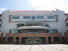
Anping District office
|
|||||||||||||
| Chinese | |||||||||||||
|---|---|---|---|---|---|---|---|---|---|---|---|---|---|
|
|||||||||||||
| Transcriptions | |
|---|---|
| Standard Mandarin | |
| Hanyu Pinyin | Ānpíng |
| Wade–Giles | An-p'ing |
| Southern Min | |
| Hokkien POJ | An-pêng |
Coordinates: 22°59′36.52″N 120°9′53.47″E / 22.9934778°N 120.1648528°E
Anping District is a district of Tainan on Taiwan. In March 2012, it was named one of the Top 10 Small Tourist Towns by the Tourism Bureau of Taiwan.
The older place name of Tayouan derives from the ethnonym of a nearby Taiwanese aboriginal tribe, and was written by the Dutch and Portuguese variously as Taiouwang, Tayowan, etc. In his translations of Dutch records, missionary William Campbell used the variant Tayouan and wrote that Taoan and Taiwan also occur. As Dutch spelling varied greatly at the time (see History of Dutch orthography), other variants may be seen. The name was also transliterated into Chinese characters variously as , , , , and 梯窝灣.
After the Dutch were ousted c. 1661 by Koxinga, Han immigrants renamed the area "Anping" after the Anping Bridge in Quanzhou, Fujian. Soon after Qing rule was established in 1683, the name "Taiwan" (臺灣) was officially used to refer to the whole island with the establishment of Taiwan Prefecture.
...
Wikipedia
