Sherwood, North Dakota
| Sherwood, North Dakota | |
|---|---|
| City | |
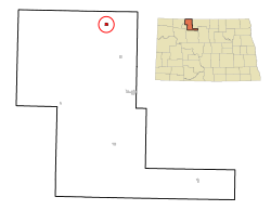
 Location of Sherwood, North Dakota |
|
| Coordinates: 48°57′41″N 101°37′55″W / 48.96139°N 101.63194°WCoordinates: 48°57′41″N 101°37′55″W / 48.96139°N 101.63194°W | |
| Country | United States |
| State | North Dakota |
| County | Renville |
| Founded | 1904 |
| Incorporated | 1916 |
| Area | |
| • Total | 0.31 sq mi (0.80 km2) |
| • Land | 0.31 sq mi (0.80 km2) |
| • Water | 0 sq mi (0 km2) |
| Elevation | 1,644 ft (501 m) |
| Population (2010) | |
| • Total | 242 |
| • Estimate (2014) | 252 |
| • Density | 780.6/sq mi (301.4/km2) |
| Time zone | Central (CST) (UTC-6) |
| • Summer (DST) | CDT (UTC-5) |
| ZIP code | 58782 |
| Area code(s) | 701 |
| FIPS code | 38-72540 |
| GNIS feature ID | 1032053 |
Sherwood is a city in Renville County, North Dakota, United States. The population was 242 as of the 2010 census. It is part of the Minot Micropolitan Statistical Area. It was founded in 1904 and named after Sherwood H. Sleeper, a Mohall banker who had owned land in the area.
Sherwood's weather station has one of the lowest (if not the lowest) yearly precipitation levels in North Dakota, with an annual normal of 13.13 inches (1971–2000).
Sherwood is designated by the U.S. Customs and Border Protection agency as a port of entry between the United States and Canada.
Sherwood is located at 48°57′41″N 101°37′55″W / 48.96139°N 101.63194°W (48.961469, -101.631889).
According to the United States Census Bureau, the city has a total area of 0.31 square miles (0.80 km2), all of it land.
As of the census of 2010, there were 242 people, 110 households, and 70 families residing in the city. The population density was 780.6 inhabitants per square mile (301.4/km2). There were 133 housing units at an average density of 429.0 per square mile (165.6/km2). The racial makeup of the city was 99.2% White and 0.8% from two or more races. Hispanic or Latino of any race were 0.4% of the population.
...
Wikipedia
