Sheldon, New York
| Sheldon, New York | |
|---|---|
| Town | |
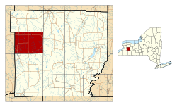
 Location within Wyoming County and New York |
|
| Location within the state of New York | |
| Coordinates: 42°43′36″N 78°22′27″W / 42.72667°N 78.37417°W | |
| Country | United States |
| State | New York |
| County | Wyoming |
| Area | |
| • Total | 47.4 sq mi (122.7 km2) |
| • Land | 47.3 sq mi (122.6 km2) |
| • Water | 0.0 sq mi (0.1 km2) |
| Elevation | 1,490 ft (454 m) |
| Population (2010) | |
| • Total | 2,409 |
| • Density | 51/sq mi (20/km2) |
| Time zone | Eastern (EST) (UTC-5) |
| • Summer (DST) | EDT (UTC-4) |
| ZIP code | 14145 |
| Area code(s) | 585 |
| FIPS code | 36-66773 |
| GNIS feature ID | 0979488 |
| Website | www.townofsheldon.com |
Sheldon is a town in Wyoming County, New York. The population was 2,409 at the 2010 census. The Town of Sheldon is on the west border of Wyoming County. The town is southeast of Buffalo.
The Town of Sheldon was founded in 1808 from part of the Town of Batavia. In 1811, the Town of Attica was formed from part of Sheldon, and the Towns of Bennington and Arcade were taken off in 1818.
According to the United States Census Bureau, the town has a total area of 47.4 square miles (123 km2), of which 47.3 square miles (123 km2) is land and 0.04 square miles (0.10 km2) (0.06%) is water.
The west town line is the border of Erie County, New York. Cayuga Creek flows northward through the east part of the town and the Buffalo Creek flows through the southwest part.
U.S. Route 20A passes across the north part of the town and intersects New York State Route 77 at Persons Corners.
As of the census of 2000, there were 2,561 people, 916 households, and 707 families residing in the town. The population density was 54.1 people per square mile (20.9/km²). There were 973 housing units at an average density of 20.6 per square mile (7.9/km²). The racial makeup of the town was 99.61% White, 0.04% African American, 0.04% Asian, 0.04% Pacific Islander, 0.16% from other races, and 0.12% from two or more races. Hispanic or Latino of any race were 0.23% of the population.
...
Wikipedia

