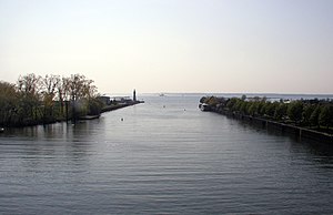
Buffalo River (New York)
| Buffalo River | |
| River | |
|
Buffalo River where it empties into Lake Erie. The lighthouse on the left of the river is the Buffalo Main Light
|
|
| Country | United States |
|---|---|
| State | New York |
| Counties | Erie, Wyoming |
| Tributaries | |
| - left | Cayuga Creek |
| - right | Buffalo Creek (New York), Cazenovia Creek |
| City | Buffalo |
| Source | |
| - elevation | 1,450 ft (442 m) |
| - coordinates | 42°35′38″N 78°28′15″W / 42.59389°N 78.47083°W |
| Mouth | Lake Erie |
| - location | Buffalo |
| - elevation | 570 ft (174 m) |
| - coordinates | 42°52′42″N 78°53′11″W / 42.87833°N 78.88639°WCoordinates: 42°52′42″N 78°53′11″W / 42.87833°N 78.88639°W |
| Length | 8 mi (13 km) approximately |
| Basin | 447 sq mi (1,158 km2) total watershed |
The Buffalo River drains a 447-square-mile (1,160 km2) watershed in New York state, emptying into the eastern end of Lake Erie at the City of Buffalo. The river has three tributaries: Cayuga Creek, Buffalo Creek, and Cazenovia Creek.
The Buffalo River has been important to the development of western New York, including as the terminus for the Erie Canal beginning in 1825, and later as an industrial area with uses including grain elevators, steel mills and chemical production. When shipping began to bypass the Erie Canal in the 1950s, and later with the decline of heavy industry in the region, the transportation and industrial use of the river greatly declined and many adjacent factories and grain mills were abandoned. The river and adjacent sites have been the focus of efforts over several decades to improve water quality and restore habitat, most recently in 2011 with the commencement of the Buffalo River Restoration Project.
The Buffalo River flows westward from the point of confluence, passing through residential and heavily industrialized parts of the city. The river includes a 6.2-mile (10.0 km) federal navigation channel maintained by the United States Army Corps of Engineers at a depth of 23 feet (7.0 m) below lake level (along with an additional 1.4 miles [2.3 km] of the City Ship Canal). Because of this designation, bridges in the navigable part of the river are required to allow for passage of high vessels, and many of them are drawbridges. The very low hydraulic gradient of the river, along with the dredging, gives the river an estuarine-like character. Much of the shoreline is hardened by riprap, bulkheads and other structures, and little vegetation remains along the banks. The river enters the lake between a United States Coast Guard station and the Erie Basin Marina. The grounds of the Coast Guard station include the Buffalo Main Light, established in 1833 and listed on the National Register of Historic Places.
...
Wikipedia

