Sawasiray
| Sahuasiray | |
|---|---|
| Ccolque Cruz | |

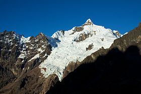
Snow covered Sahuasiray.
|
|
| Highest point | |
| Elevation | 5,818 m (19,088 ft) |
| Prominence | 1,920 m (6,300 ft) |
| Listing | Ultra |
| Coordinates | 13°12′50″S 71°59′18″W / 13.21389°S 71.98833°WCoordinates: 13°12′50″S 71°59′18″W / 13.21389°S 71.98833°W |
| Geography | |
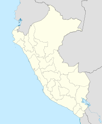
| Location | Cusco, Peru |
| Parent range | Urubamba, Andes |
| Climbing | |
| First ascent | Sahuasiray N: 1-1963 via E. ridge. Sahuasiray S: 1-1968 |
Sahuasiray (possibly from Quechua sawa matrimony, siray to sew,), Sawasiray,Colque Cruz or Ccolque Cruz (possibly from Aymara and Quechua qullqi silver, money, Spanish cruz cross, "silver cross"), is one of the highest mountains in the Urubamba mountain range in the Andes of Peru, about 5,818 metres (19,088 ft) high. It lies in the Cusco Region, Calca Province, northwest of Calca. It is situated northeast of Ch'iqun and Kancha Kancha Q'asa, southeast of Siriwani and northwest of Kuntur Wachana.
...
Wikipedia

