Sahara desert
| Sahara | |
| The Great Desert | |
| Desert | |
|
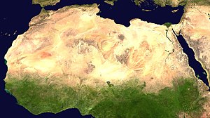
A satellite image of the Sahara by NASA World Wind.
|
|
| Countries | Algeria, Chad, Egypt, Libya, Mali, Mauritania, Morocco, Niger, Sudan, Tunisia |
|---|---|
| Highest point | Emi Koussi 3,415 m (11,204 ft) |
| - coordinates | 19°47′36″N 18°33′6″E / 19.79333°N 18.55167°E |
| Lowest point | Qattara Depression −133 m (−436 ft) |
| - coordinates | 30°0′0″N 27°5′0″E / 30.00000°N 27.08333°E |
| Length | 4,800 km (2,983 mi), E/W |
| Width | 1,800 km (1,118 mi), N/S |
| Area | 9,200,000 km2 (3,552,140 sq mi) |
| Biome | Desert |
The Sahara (Arabic: الصحراء الكبرى, aṣ-ṣaḥrāʾ al-kubrā , 'the Greatest Desert') is the largest hot desert and the third largest desert in the world after Antarctica and the Arctic. Its area of 9,200,000 square kilometres (3,600,000 sq mi) is comparable to the area of the United States.
The desert comprises much of North Africa, excluding the fertile region on the Mediterranean Sea coast, the Atlas Mountains of the Maghreb, and the Nile Valley in Egypt and Sudan. It stretches from the Red Sea in the east and the Mediterranean in the north to the Atlantic Ocean in the west, where the landscape gradually changes from desert to coastal plains. To the south, it is bounded by the Sahel, a belt of semi-arid tropical savanna around the Niger River valley and the Sudan Region of Sub-Saharan Africa.
The Sahara can be divided into several regions including: the western Sahara, the central Ahaggar Mountains, the Tibesti Mountains, the Aïr Mountains, the Ténéré desert, and the Libyan Desert.
...
Wikipedia

