Ruschein
| Ruschein | ||
|---|---|---|
| Former municipality of Switzerland | ||
 |
||
|
||
| Coordinates: 46°47′N 9°11′E / 46.783°N 9.183°ECoordinates: 46°47′N 9°11′E / 46.783°N 9.183°E | ||
| Country | Switzerland | |
| Canton | Graubünden | |
| District | Surselva | |
| Area | ||
| • Total | 12.54 km2 (4.84 sq mi) | |
| Elevation | 1,155 m (3,789 ft) | |
| Population (Dec 2011) | ||
| • Total | 345 | |
| • Density | 28/km2 (71/sq mi) | |
| Postal code | 7154 | |
| SFOS number | 3580 | |
| Surrounded by | Falera, Glarus Süd (GL), Ilanz, Laax, Ladir, Schluein, Schnaus, Siat | |
| Website |
www SFSO statistics |
|
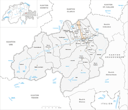
Ruschein is a municipality in the district of Surselva in the canton of Graubünden in Switzerland. Its official language is the Sursilvan dialect of Romansh. On 1 January 2014 the former municipalities of Ruschein, Castrisch, Ilanz, Ladir, Luven, Pitasch, Riein, Schnaus, Sevgein, Duvin, Pigniu, Rueun and Siat merged into the new municipality of Ilanz/Glion.
Ruschein is first mentioned in 765 as Rucene.
Before the merger, Ruschein had a total area of 12.5 km2 (4.8 sq mi). Of this area, 43.1% is used for agricultural purposes, while 25.8% is forested. Of the rest of the land, 3% is settled (buildings or roads) and the remainder (28.2%) is non-productive (rivers, glaciers or mountains).
The former municipality is located in the Ilanz sub-district of the Surselva district. It is located on a terrace on the northern Vorderrhein valley wall. It consists of the village of Ruschein and the alpine herding settlement of Alp da Ruschein in the furthest Val da Siat.
Ruschein had a population (as of 2011) of 345. As of 2008[update], 4.9% of the population was made up of foreign nationals. Over the last 10 years the population has decreased at a rate of -4.2%. Most of the population (as of 2000[update]) speaks Romansh(69.4%), with German being second most common (26.7%) and Albanian being third ( 1.4%).
...
Wikipedia


