Castrisch
| Castrisch | ||
|---|---|---|
| Former municipality of Switzerland | ||
 |
||
|
||
| Coordinates: 46°46′N 9°13′E / 46.767°N 9.217°ECoordinates: 46°46′N 9°13′E / 46.767°N 9.217°E | ||
| Country | Switzerland | |
| Canton | Graubünden | |
| District | Surselva | |
| Area | ||
| • Total | 7.19 km2 (2.78 sq mi) | |
| Elevation | 722 m (2,369 ft) | |
| Population (Dec 2011) | ||
| • Total | 396 | |
| • Density | 55/km2 (140/sq mi) | |
| Postal code | 7126 | |
| SFOS number | 3571 | |
| Surrounded by | Ilanz, Riein, Sagogn, Schluein, Sevgein, Valendas | |
| Website | SFSO statistics |
|
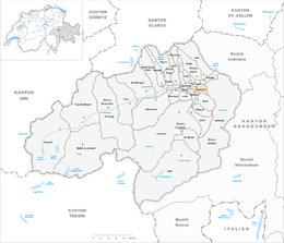
Castrisch (![]() [kɐˈʃtʁiʃ] ) is a former municipality in the district of Surselva in the Swiss canton of Graubünden. Until 1943, it was officially known as Kästris. On 1 January 2014 the former municipalities of Castrisch, Ilanz, Ladir, Luven, Pitasch, Riein, Ruschein, Schnaus, Sevgein, Duvin, Pigniu, Rueun and Siat merged into the new municipality of Ilanz/Glion.
[kɐˈʃtʁiʃ] ) is a former municipality in the district of Surselva in the Swiss canton of Graubünden. Until 1943, it was officially known as Kästris. On 1 January 2014 the former municipalities of Castrisch, Ilanz, Ladir, Luven, Pitasch, Riein, Ruschein, Schnaus, Sevgein, Duvin, Pigniu, Rueun and Siat merged into the new municipality of Ilanz/Glion.
Castrisch is first mentioned in 765 as Castrices.
Before the merger, Castrisch had a total area of 7.2 km2 (2.8 sq mi). Of this area, 40.8% is used for agricultural purposes, while 51.3% is forested. Of the rest of the land, 3.3% is settled (buildings or roads) and the remainder (4.6%) is non-productive (rivers, glaciers or mountains).
The former municipality is located in the Ilanz sub-district of the Surselva district. It lies on the old route over the Vorderrhein river and on the route from Schluein to Safien. Until 1943 Castrisch was known by its German name as Kästris.
...
Wikipedia


