Rostov Region
|
Rostov Oblast Ростовская область (Russian) |
|||||
|---|---|---|---|---|---|
| — Oblast — | |||||
|
|||||
|
|
|||||
|
|||||
|
|
|||||
| Political status | |||||
| Country | Russia | ||||
| Federal district | Southern | ||||
| Economic region | North Caucasus | ||||
| Established | September 13, 1937 | ||||
| Administrative center | Rostov-on-Don | ||||
| Government (as of August 2014) | |||||
| • Governor | Vasily Golubev | ||||
| • Legislature | Legislative Assembly | ||||
| Statistics | |||||
| Area (as of the 2002 Census) | |||||
| • Total | 100,800 km2 (38,900 sq mi) | ||||
| Area rank | 32nd | ||||
| Population (2010 Census) | |||||
| • Total | 4,277,976 | ||||
| • Rank | 6th | ||||
| • Density | 42.44/km2 (109.9/sq mi) | ||||
| • Urban | 67.2% | ||||
| • Rural | 32.8% | ||||
| Population (January 2013 est.) | |||||
| • Total | 4,254,600 | ||||
| Time zone(s) | MSK (UTC+03:00) | ||||
| ISO 3166-2 | RU-ROS | ||||
| License plates | 61, 161 | ||||
| Official languages | Russian | ||||
| Official website | |||||
|
|
|
|---|---|
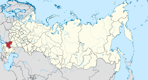
Rostov Oblast (Russian: Росто́вская о́бласть, tr. Rostovskaya oblast; IPA: [rɐˈstofskəjə ˈobləsʲtʲ]) is a federal subject of Russia (an oblast), located in the Southern Federal District. The oblast has an area of 100,800 square kilometers (38,900 sq mi) and a population of 4,277,976 (2010 Census), making it the sixth most populous federal subject in Russia. Its administrative center is the city of Rostov-on-Don, which also became the administrative center of the Southern Federal District in 2002.
Rostov Oblast borders Ukraine and also Volgograd and Voronezh Oblasts in the north, Krasnodar and Stavropol Krais in the south, and the Republic of Kalmykia in the east.
It is within the Russian Southern Federal District.
The Don River, one of Europe's largest rivers, flows through the oblast for part of its course. Lakes cover only 0.4% of the oblast's area.
It was formed in 1937 out of the Azov-Black Sea Krai.
Population: 4,277,976 (2010 Census);4,404,013 (2002 Census);4,308,654 (1989 Census).
...
Wikipedia


