Río de La Plata
| Río de la Plata | |
| River Plate, La Plata River | |
|
NASA photo of the Río de la Plata looking from northwest to southeast. Buenos Aires is visible on the right side near the Paraná River delta. River sediments turn the water brown to the vicinity of Montevideo, visible on the left coast.
|
|
| Name origin: Spanish, "river of silver" | |
| Countries | Argentina, Uruguay |
|---|---|
| Tributaries | |
| - left | Uruguay River, San Juan River, Santa Lucía River |
| - right | Paraná River, Luján River, Salado River |
| Cities | La Plata, Buenos Aires, Montevideo, San Fernando, San Isidro, Vicente López, Avellaneda, Quilmes, Berazategui, Hudson, Punta Lara, Atalaya, San Clemente del Tuyú, Ciudad del Plata, Ciudad de la Costa, Colonia del Sacramento |
| Source | confluence of Paraná and Uruguay Rivers |
| - elevation | 0 m (0 ft) |
| - coordinates | 34°0′5″S 58°23′37″W / 34.00139°S 58.39361°W |
| Mouth | Atlantic Ocean |
| - location | Argentine Sea, Argentina & Uruguay |
| - elevation | 0 m (0 ft) |
| - coordinates | 35°40′S 55°47′W / 35.667°S 55.783°WCoordinates: 35°40′S 55°47′W / 35.667°S 55.783°W |
| Length | 290 km (180 mi) 4,876 km (3,030 mi) including the Paraná |
| Width | 220 km (137 mi) |
| Basin | 3,170,000 km2 (1,224,000 sq mi) |
| Discharge | for mouth |
| - average | 22,000 m3/s (777,000 cu ft/s) |
|
Map of the Río de la Plata basin, showing the Río de la Plata at the mouths of the Paraná and Uruguay rivers, near Buenos Aires
|
|
|
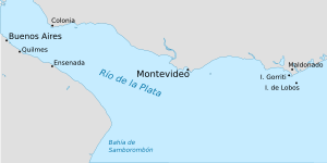
Map of the Río de la Plata, showing cities in Argentina and Uruguay
|
|
The Río de la Plata (Spanish pronunciation: [ˈri.o ðe la ˈplata], River of Silver) — rendered River Plate in British English and the Commonwealth and La Plata River (occasionally Plata River) in other English-speaking countries — is the river and estuary formed by the confluence of the Uruguay and the Paraná rivers. It empties into the Atlantic Ocean, forming a funnel-shaped indentation on the southeastern coastline of South America.
The river is about 290 kilometres (180 mi) long, and it widens from about 2 kilometres (1.2 mi) at its source to about 220 kilometres (140 mi) at its mouth. It forms part of the border between Argentina and Uruguay, with the major ports and capital cities of Buenos Aires and Montevideo on its western and northern shores, respectively. The coasts of La Plata are the most densely populated areas of Argentina and Uruguay.
The Río de la Plata begins at the confluence of the Uruguay and Paraná rivers at Punta Gorda and flows eastward into the South Atlantic Ocean. No clear physical boundary marks the river's eastern end; the International Hydrographic Organization defines the eastern boundary of the Río de la Plata as "a line joining Punta del Este, Uruguay and Cabo San Antonio, Argentina".
...
Wikipedia


