Paraná Delta
| Paraná Delta | |
|---|---|

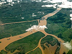
Aerial view of the Lower Delta, north of Buenos Aires
|
|
| Country | Argentina |
| Basin features | |
| Basin size | 14,000 square kilometres (5,400 sq mi) |
| Physical characteristics | |
| Length | 320 kilometres (200 mi) |
| Discharge |
|
The Paraná Delta (Spanish: Delta del Paraná) is the delta of the Paraná River in Argentina and it consists of several islands known as the Islas del Paraná. The Paraná flows north–south and becomes an alluvial basin (a flood plain) between the Argentine provinces of Entre Ríos, Santa Fe and Buenos Aires then emptying into the Río de la Plata.
It covers about 14,000 square kilometres (5,400 sq mi) and starts to form between the cities of Santa Fe and Rosario, where the river splits into several arms, creating a network of islands and wetlands. Most of it is in the jurisdiction of Entre Ríos Province, and parts in the north of Buenos Aires Province.
The Paraná Delta is conventionally divided into three parts:
The total length of the delta is about 320 kilometres (200 mi), and its width varies between 18 and 60 kilometres (11 and 37 mi). It carries 160 million tonnes of suspended sediment (about half of it coming from the Bermejo River through the Paraguay River) and advances from 50 to 90 metres (160 to 300 ft) (depending on the source) per year over the Río de la Plata. It is the world's only river delta that is in contact not with the sea but with another river.
The Lower Delta was the site of the first modern settlements in the Paraná-Plata basin and is today densely populated, being the agricultural and industrial core of Argentina and host to several major ports. The main course of the Paraná lies on the west of the delta, and is navigable downstream from Puerto General San Martín by ships up to Panamax kind.
...
Wikipedia
