Putnam, Connecticut
| Putnam, Connecticut | ||
|---|---|---|
| Town | ||

Main Street about 1915
|
||
|
||
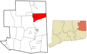
 Location in Windham County and the state of Connecticut. |
||
| Coordinates: 41°54′22″N 71°52′13″W / 41.90611°N 71.87028°WCoordinates: 41°54′22″N 71°52′13″W / 41.90611°N 71.87028°W | ||
| Country |
|
|
| State |
|
|
| County | Windham | |
| NECTA | Worcester, MA | |
| Region | Northeastern Connecticut | |
| Incorporated | 1855 | |
| Government | ||
| • Type | Selectman-Town Meeting | |
| • Mayor | Anthony Falzarano (D) | |
| • Board of Selectmen | Alma D. Morey (D), Deputy Mayor Owen A. Tarr (D) J. Scott Pempek (D) Douglas Cutler, Jr. (R) Renee Lasko (D) Roy Simmons (R) |
|
| • State Senator |
Mae Flexer (D-29th District) |
|
| • State Rep. | Daniel Rovero (D-51st District) |
|
| Area | ||
| • Total | 20.4 sq mi (52.8 km2) | |
| • Land | 20.3 sq mi (52.6 km2) | |
| • Water | 0.1 sq mi (0.3 km2) | |
| Elevation | 410 ft (125 m) | |
| Population (2010) | ||
| • Total | 9,584 | |
| • Density | 472/sq mi (182/km2) | |
| Time zone | Eastern (UTC-5) | |
| • Summer (DST) | Eastern (UTC-4) | |
| ZIP code | 06260 | |
| Area code(s) | 860 | |
| FIPS code | 09-62710 | |
| GNIS feature ID | 0213494 | |
| Website | http://www.putnamct.us/ | |
Putnam is a town in Windham County, Connecticut, United States. The population was 9,584 at the 2010 census. It is home to WINY, an AM radio station.
Putnam, originally known as Aspinock, then part of Killingly, is a New England mill town incorporated in 1855. Created from sections of Killingly, Pomfret, and Thompson, the town was named in honor of Revolutionary War General Israel Putnam.
Putnam was a key contributor in providing clothing and other goods to the Civil War soldiers. There were numerous mills and a train ran through the town, providing transportation for the goods being produced.
On August 19, 1955, Putnam was devastated by floods from torrential downpours caused by two hurricanes, which hit Connecticut within the span of a week. Hurricane Connie affected Connecticut on August 13, dropping between four and six inches (152 mm) of rain across the state. Hurricane Diane soaked the state with 14 inches (360 mm) of rain on August 18–19. The result was flooding in many of the state's rivers, including the Quinebaug River. The resulting torrent of water destroyed homes, businesses and factories. Floating magnesium barrels burst, lighting up the night. The railroad bed was washed away.
...
Wikipedia

