Worcester, Massachusetts
| Worcester, Massachusetts | |||||||||||
|---|---|---|---|---|---|---|---|---|---|---|---|
| City | |||||||||||
| City of Worcester | |||||||||||
Downtown Skyline
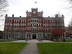
City Hall, Clark University, DCU Center, American Antiquarian Society, Worcester Public Library Paul Revere Road, Catharine Street, Union Station |
|||||||||||
|
|||||||||||
| Nickname(s): The City of the Seven Hills, The Heart of the Commonwealth, Wormtown, Woo-town, The Woo | |||||||||||
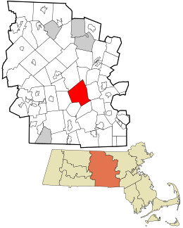
 Location in Worcester County and the state of Massachusetts |
|||||||||||
| Location in the United States | |||||||||||
| Coordinates: 42°16′N 71°48′W / 42.267°N 71.800°WCoordinates: 42°16′N 71°48′W / 42.267°N 71.800°W | |||||||||||
| Country | United States | ||||||||||
| State | Massachusetts | ||||||||||
| County | Worcester | ||||||||||
| Settled | 1673 | ||||||||||
| Incorporated as a town | June 14, 1722 | ||||||||||
| Incorporated as a city | February 29, 1848 | ||||||||||
| Government | |||||||||||
| • Type | Council-manager | ||||||||||
| • City Manager | Edward M. Augustus, Jr. | ||||||||||
| • Mayor | Joseph Petty | ||||||||||
| Area | |||||||||||
| • City | 38.6 sq mi (99.9 km2) | ||||||||||
| • Land | 37.6 sq mi (97.3 km2) | ||||||||||
| • Water | 1.0 sq mi (2.6 km2) | ||||||||||
| Elevation | 480 ft (146 m) | ||||||||||
| Population (2014 est.) | |||||||||||
| • City | 183,016 | ||||||||||
| • Density | 4,678.1/sq mi (1,807.8/km2) | ||||||||||
| • Metro | 923,672 | ||||||||||
| Time zone | Eastern (UTC-5) | ||||||||||
| • Summer (DST) | Eastern (UTC-4) | ||||||||||
| ZIP code | 01601–01610, 01612–01615, 01653–01655 | ||||||||||
| Area code(s) | 508 / 774 | ||||||||||
| FIPS code 0 | 25-82000 | ||||||||||
| GNIS feature ID | 0617867 | ||||||||||
| Website | www |
||||||||||
| County-level state agency heads | |
|---|---|
| Clerk of Courts: | Dennis P. McManus (D) |
| District Attorney: | Joseph D. Early, Jr. (D) |
| Register of Deeds: | Anthony J. Vigliotti (D) |
| Register of Probate: | Stephanie K. Fattman (R) |
| County Sheriff: | Lew Evangelidis (R) |
| State government | |
| State Representative(s): | James O'Day (D)
Kate Campanale (R) |
| State Senator(s): | Michael Moore (D) Harriet L. Chandler (D) |
| Governor's Councilor(s): | Jen Caissie (R) |
| Federal government | |
| U.S. Representative(s): | James P. McGovern (D-2nd District), |
| U.S. Senators: | Elizabeth Warren (D), Ed Markey (D) |
Worcester (/ˈwʊstər/ WUUSS-tər, is a city and the county seat of Worcester County, Massachusetts, United States. Named after Worcester, England, as of the 2010 Census the city's population was 181,045, making it the second most populous city in New England after Boston. Worcester is located approximately 40 miles (64 km) west of Boston, 50 miles (80 km) east of Springfield and 40 miles (64 km) north of Providence. Due to its location in Central Massachusetts, Worcester is known as the "Heart of the Commonwealth", thus, a heart is the official symbol of the city. However, the heart symbol may also have its provenance in lore that the mass-produced Valentine's Day card was invented in the city.
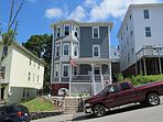
Worcester was considered its own region for centuries; however, with the encroachment of Boston's suburbs in the 1970s after the construction of Interstate 495 and Interstate 290, it now marks the western periphery of the Boston-Worcester-Providence (MA-RI-NH) U.S. Census Combined Statistical Area (CSA), or Greater Boston. The city features many examples of Victorian-era mill architecture.
...
Wikipedia


