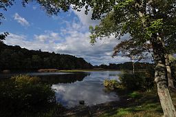
Quinebaug River
| Quinebaug River | |
| River | |
|
The river in Thompson, CT
|
|
| Country | United States |
|---|---|
| States | Connecticut, Massachusetts |
| Counties | New London, CT, Windham, CT, Worcester, MA, Hampden, MA |
| Tributaries | |
| - left | French River |
| Source | Holland Pond |
| - location | Holland, Hampden County, Massachusetts, United States |
| - elevation | 645 ft (197 m) |
| Mouth | Empties into Shetucket River |
| - location | Preston and Lisbon, New London County, Connecticut, United States |
| - elevation | 30 ft (9 m) |
| Discharge | for Jewett City, CT |
| - average | 467 cu ft/s (13 m3/s) |
| - max | 2,640 cu ft/s (75 m3/s) Annual mean, 1938 |
| - min | 40 cu ft/s (1 m3/s) Annual mean, 1931 |
42°04′55″N 72°09′49″W / 42.082071°N 72.163666°W
41°33′22″N 72°02′46″W / 41.556°N 72.046°W
For the river from New Haven, CT: Quinnipiac River
The Quinebaug River is a river in south-central Massachusetts and eastern Connecticut, with watershed extending into western Rhode Island. The name "Quinebaug" comes from the southern New England Native American term, spelled variously Qunnubbâgge, Quinibauge, etc., meaning "long pond", from qunni-, "long", and -paug, "pond". The river is one of the namesake rivers in the Quinebaug and Shetucket Rivers Valley National Heritage Corridor.
The river is about 69 miles (111 km) in length. It originates from East Brimfield Lake and ponds northwest of Sturbridge, Massachusetts, flows generally southeast and south through Connecticut (Putnam, Danielson, Plainfield, Canterbury and Jewett City), the river joins Aspinook pond which begins in Canterbury and ends in Jewett City. The river then continues to the Shetucket River northeast of Norwich. That river flows from there into the Thames River and drains into the Long Island Sound. It is dammed in its upper reaches at East Brimfield Dam, Westville Dam, and West Thompson Dam all for flood control, as well as numerous mill dams which powered mills along the river's course. Some of these still provide hydroelectric power today.
...
Wikipedia

