Pre-1964 Legislative Route 3 (California)
| State Route 99 | ||||
|---|---|---|---|---|
| Golden State Highway | ||||

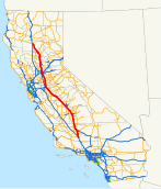
SR 99 highlighted in red
|
||||
| Route information | ||||
| Defined by | ||||
| Maintained by Caltrans | ||||
| Length: | 424.85 mi (683.73 km) | |||
| Existed: | 1928 as US 99, 1964 as SR 99 – present | |||
| Major junctions | ||||
| South end: |
|
|||
| North end: |
|
|||
| Location | ||||
| Counties: | Kern, Tulare, Fresno, Madera, Merced, Stanislaus, San Joaquin, Sacramento, Sutter, Butte, Tehama | |||
| Highway system | ||||
|
||||
State Route 99 (SR 99), commonly known as Highway 99 or, simply, as 99 (without any further designation), is a north–south state highway in the U.S. state of California, stretching almost the entire length of the Central Valley. From its southern end at Interstate 5 (I-5) near Wheeler Ridge to its northern end at SR 36 near Red Bluff, SR 99 goes through the densely populated eastern parts of the valley. Cities served include Bakersfield, Delano, Tulare, Visalia, Kingsburg, Selma, Fresno, Madera, Merced, Modesto, , Sacramento, Turlock, Yuba City, and Chico.
The highway is a remnant of the former Mexico to Canada U.S. Route 99 (US 99), which was decommissioned in 1972 after being functionally replaced by I-5 for long-distance traffic. Almost the entirety of the roadway from Wheeler Ridge to Sacramento has been upgraded as of January 2016 to a freeway at least four lanes wide, and Caltrans plans to further upgrade the segment to a minimum width of six lanes and also bring it into compliance with Interstate Highway standards, as a parallel route to I-5 for Los Angeles–Sacramento traffic. North of Sacramento, the road ranges from a rural two-lane road to a four-lane freeway.
...
Wikipedia

