Manteca, California
| City of Manteca | |
|---|---|
| City | |

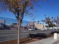
From the corner of Yosemite and Main in Manteca
|
|
| Nickname(s): The Family City | |
 Location in San Joaquin County and the state of California |
|
| Location in the United States | |
| Coordinates: 37°48′10″N 121°13′15″W / 37.80278°N 121.22083°WCoordinates: 37°48′10″N 121°13′15″W / 37.80278°N 121.22083°W | |
| Country |
|
| State |
|
| County | San Joaquin |
| Incorporated | June 5, 1918 |
| Government | |
| • Mayor | Stephen DeBrum |
| • State senator | Cathleen Galgiani (D) |
| • Assemblymember | Heath Flora (R) |
| • U. S. rep. | Jeff Denham (R) |
| Area | |
| • Total | 17.757 sq mi (45.991 km2) |
| • Land | 17.733 sq mi (45.929 km2) |
| • Water | 0.024 sq mi (0.062 km2) 0.13% |
| Elevation | 36 ft (11 m) |
| Population (April 1, 2010) | |
| • Total | 67,096 |
| • Estimate (2013) | 71,948 |
| • Density | 3,800/sq mi (1,500/km2) |
| Time zone | Pacific (UTC−8) |
| • Summer (DST) | PDT (UTC−7) |
| ZIP codes | 95336, 95337 |
| Area code | 209 |
| FIPS code | 06-45484 |
| GNIS feature IDs | 1659046, 2411024 |
| Website | www |
Manteca is a city in San Joaquin County, California. The city's estimated 2013 population was 71,948.
Manteca is a city in the Central Valley of California, 76 miles east of San Francisco. It was founded in 1861 by Joshua Cowell. Cowell claimed around 1,000 acres (4.0 km2) and built houses on what is now the corner of Main and Yosemite, where Bank of America now stands. In 1873, the Central Pacific Railroad laid track directly through the area. The residents wanted to refer to their new train station as "Cowell Station", but there was already a Cowell Station near Tracy. So, the residents agreed to change the name of the community, choosing "Monteca" as the new name. This was misprinted as "Manteca" (Spanish for lard) by the railroad, and the misspelled version was eventually accepted as the name of the town. This misspelling thus became a hilarious town-held joke that would be laughed at throughout generations to come. Hence, in 1918, Manteca was incorporated as a city, and Joshua Cowell became its first mayor.
Manteca fashions itself the "Family City", and it lies at a crossroads of major highways and railroads. As recently as the 1970s, Manteca existed primarily on agriculture and was still barely a stop between two freeways, Interstate 5 and State Route 99. The continuing rise in Bay Area housing prices caused Bay Area residents to look further eastward for cheaper places to live. Since the construction of the 120 bypass portion of State Route 120, Manteca has become a popular choice for these commuters. The 1990s saw an increase in the city's population and the construction of its third high school, the first two being Manteca High School and East Union High School. The population of Manteca continues to increase, with some housing being constructed on what was once farmland to the north and southeast.
There is a school called East Union in Manteca. It was first used in 1857 for a school established in what is now Manteca. The school was named East Union in order to differentiate it from Union School, which is in an area now within Lathrop, California. A cemetery named East Union was established in 1872, and it remains one of San Joaquin County's oldest landmarks. A road bordering the cemetery was named Union Road after the cemetery and is now one of the main streets through the city. In 1966, the city of Manteca started another high school to relieve overcrowding in Manteca High School. The new school was given the name East Union High School in tribute to an old farmhouse school.
...
Wikipedia

