Lathrop, California
| City of Lathrop | |
|---|---|
| City | |
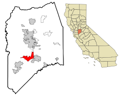
 Location in San Joaquin County and the state of California |
|
| Location in the United States | |
| Coordinates: 37°49′1″N 121°17′19″W / 37.81694°N 121.28861°WCoordinates: 37°49′1″N 121°17′19″W / 37.81694°N 121.28861°W | |
| Country |
|
| State |
|
| County | San Joaquin |
| Incorporated | July 1, 1989 |
| Government | |
| • Mayor | Sonny Dhaliwal |
| • Senate | Cathleen Galgiani (D) |
| • Assembly | Heath Flora (R) |
| • U. S. Congress | Jerry McNerney (D) |
| • City manager | Stephen Salvatore |
| Area | |
| • Total | 23.033 sq mi (59.655 km2) |
| • Land | 21.931 sq mi (56.800 km2) |
| • Water | 1.102 sq mi (2.854 km2) 4.79% |
| Elevation | 23 ft (7 m) |
| Population (April 1, 2010) | |
| • Total | 22,112 |
| • Estimate (2013) | 19,626 |
| • Density | 960/sq mi (370/km2) |
| Time zone | PST (UTC-8) |
| • Summer (DST) | PDT (UTC-7) |
| ZIP code | 95330 |
| Area code(s) | 209 |
| FIPS code | 06-40704 |
| GNIS feature ID | 1658948 |
| Website | www |
Lathrop is a city located in San Joaquin County, California, United States. At the 2010 census Lathrop’s population was 18,023. The city is located in Northern California at the intersection of Interstate 5 and SR 120.
Lathrop was platted when the railroad was extended to that point. A post office has been in operation at Lathrop since 1871. The city was named for the maiden name of the wife of Leland Stanford. In September 1869, four months after the railheads of the transcontinental railroad met at Promontory, Utah, the completion of the San Joaquin River Bridge at Mossdale crossing at Lathrop actually completed the west coast link.
On August 14, 1889 Chief Justice of California David S. Terry assaulted United States Supreme Court Justice Stephen J. Field, at the train station in Lathrop. Field's bodyguard United States Marshal David Neagle (formerly assigned to Tombstone, Arizona) shot and killed Terry. The events led the United States Supreme Court decision In re Neagle.
Lathrop is located at 37°49′1″N 121°17′19″W / 37.81694°N 121.28861°W (37.816904, -121.288633). The San Joaquin River is on the west side of Lathrop and has elevation of 20 feet (7 m).
...
Wikipedia

