Pratas Island
| Disputed islands Other names: Dongsha Islands |
|
|---|---|

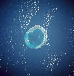
Pratas Islands from space, January 1986.
|
|
| Geography | |
| Location | South China Sea |
| Coordinates | 20°43′N 116°42′E / 20.717°N 116.700°ECoordinates: 20°43′N 116°42′E / 20.717°N 116.700°E |
| Total islands | 3 |
| Major islands | Pratas Island North Vereker Bank South Vereker Bank |
| Area | 174 ha (429.96 acres) (land), 64 ha (158.15 acres) (lagoon) |
| Length | 2.8 kilometres (1.7 mi) |
| Width | 0.865 kilometres (0.537 mi) |
| Administered by | |
| Republic of China (Taiwan) | |
|
District Municipality |
Cijin Kaohsiung |
| Claimed by | |
| People's Republic of China | |
|
County-level city Prefecture-level city Province |
Lufeng Shanwei Guangdong |
| Demographics | |
| Population | None permanent |
The Pratas Islands, also known as the Dongsha Islands, are an atoll in the north of the South China Sea consisting of three islets about 340 kilometers (211 mi) southeast of Hong Kong. Excluding their associated EEZ and territorial waters, the islets comprise about 240 ha (590 acres), including 64 ha (160 acres) of lagoon area. The People's Republic of China claims the islands, but the Republic of China (ROC) controls them and has declared them a national park. The main island of the group—Pratas Island—is the largest of the South China Sea Islands.
The English name of the islands derives from the Portuguese Ilhas das Pratas ("Silver Plate Islands"), which was given to the atoll in the 16th century owing to its round shape.
Dongsha is the pinyin romanization of the Chinese name Dōngshā Qúndǎo (t , s ), meaning "Eastern Sandy Archipelago". The name distinguishes it from Xisha, the western archipelago, better known as the Paracel Islands.
The Pratas Islands were first recorded by the Chinese over 1000 years ago in the book "Guangzhou Ji" (廣州記) written by Pei Yuan (裴淵) during the Jin Dynasty. Chinese fishermen fished in the sea around the Pratas by that time.
...
Wikipedia

