Prairie du Rocher
| Prairie du Rocher | |
|---|---|
| Village | |

A grain elevator in Prairie du Rocher
|
|
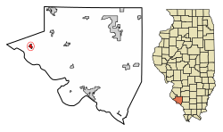
 Location of Prairie du Rocher in Randolph County, Illinois. |
|
 Location of Illinois in the United States |
|
| Coordinates: 38°04′59″N 90°05′45″W / 38.08306°N 90.09583°WCoordinates: 38°04′59″N 90°05′45″W / 38.08306°N 90.09583°W | |
| Country | United States |
| State | Illinois |
| County | Randolph |
| Precinct | Prairie du Rocher |
| Founded | 1722 |
| Area | |
| • Total | 0.57 sq mi (1.48 km2) |
| • Land | 0.57 sq mi (1.48 km2) |
| • Water | 0.00 sq mi (0.00 km2) |
| Elevation | 394 ft (120 m) |
| Population (2010) | |
| • Total | 604 |
| • Estimate (2016) | 567 |
| • Density | 992.99/sq mi (383.17/km2) |
| Time zone | CST (UTC-6) |
| • Summer (DST) | CDT (UTC-5) |
| ZIP Code(s) | 62277 |
| Area code(s) | 618 |
| FIPS code | 17-61639 |
Prairie du Rocher ("The Rock Prairie" in French) is a village in Randolph County, Illinois, United States. Founded in the French colonial period in the American Midwest, the community is located near bluffs that flank the east side of the Mississippi River along the floodplain often called the "American Bottom". The population was 604 at the 2010 census.
Prairie du Rocher is one of the oldest communities founded as a French settlement that survives in the 21st century. About four miles to the west, closer to the Mississippi River, is Fort de Chartres, site of a French military fortification and colonial headquarters established in 1720. Some buildings were reconstructed after falling into ruins, and the complex is now a state park and historical site. The fort and town were a center of government and commerce at the time when France claimed a vast territory in North America, New France or La Louisiane, which stretched from present-day Louisiana and the Illinois Country to Canada.
The village was founded in 1722 by French colonists, mostly migrants from Canada.
In 1718, Pierre Dugué de Boisbriand built the first Fort de Chartres. In 1722, St. Thérèse Langlois, a nephew of Boisbriand, founded Prairie du Rocher. The town was built on a tract of land donated by the Royal Indian Company. Boisbriand later became the commandant of the area. The town was strategically located along fertile Mississippi River bottomland. Surpluses from the productive cultivation by habitants later helped supply critical wheat and corn to New Orleans and other lower Louisiana Territory communities.
...
Wikipedia
