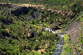
Pit River
| Pit River | |
| River | |
|
Waterfalls on the Pit River near Fall River Mills
|
|
| Name origin: Achomawi pitfall traps | |
| Country | United States |
|---|---|
| State | California |
| Districts | Modoc, Lassen, & Shasta counties |
| Tributaries | |
| - left | Ash Creek |
| - right | Squaw Creek, McCloud River |
| Source | Confluence of North and South Forks |
| - location | Near Alturas, Modoc County |
| - elevation | 4,350 ft (1,326 m) |
| - coordinates | 41°28′23″N 120°33′28″W / 41.47306°N 120.55778°W |
| Mouth | Sacramento River |
| - location | Shasta Lake, Shasta County |
| - elevation | 1,066 ft (325 m) |
| - coordinates | 40°45′23″N 122°22′14″W / 40.75639°N 122.37056°WCoordinates: 40°45′23″N 122°22′14″W / 40.75639°N 122.37056°W |
| Length | 207 mi (333 km) |
| Basin | 7,064 sq mi (18,296 km2) |
| Discharge | for Montgomery Creek, above Shasta Lake |
| - average | 4,786 cu ft/s (136 m3/s) |
| - max | 73,000 cu ft/s (2,067 m3/s) |
| - min | 30 cu ft/s (1 m3/s) |
| GNIS code | 268869 |
|
The endorheic Goose Lake was once the source of the North Fork Pit River (shown as for rare high water levels overflowing to the Pit River).
|
|
The Pit River is a major river draining from northeastern California into the state's Central Valley. The Pit, the Klamath and the Columbia are the only three rivers in the U.S. that cross the Cascade Range.
The longest tributary of the Sacramento River, it contributes as much as eighty percent of their combined water volume into the Shasta Lake reservoir; the junction of their Shasta Lake arms is 4 miles (6.4 km) northeast of Shasta Dam. The main stem of the Pit River is 207 miles (333 km) long, and some water in the system flows 265 miles (426 km) to the Sacramento River measuring from the Pit River's longest source.
The Pit River drains a sparsely populated volcanic highlands area, passing through the south end of the Cascade Range in a deep canyon northeast of Redding. The river is so named because of the pits the Achumawi dug to trap game that came to water at the river.
The river is a popular destination for fly fishing, rafting in its lower reaches, and is used to generate hydroelectricity in the powerhouses below Fall River Mills where the Pit and Fall rivers join, and at Shasta Dam. It is also used extensively for irrigation and conservation purposes.
The Pit River rises in several forks in Modoc, Lassen and Shasta counties in the northeastern corner of California. The 58-mile (93 km) South Fork Pit River - West Valley Creek - Cedar Creek source originates just southeast of Buck Mountain in the Warner Mountains, in the extreme southeastern corner of the Modoc National Forest 9 miles (14 km) west of the California–Nevada border. The South Fork is formed from the confluence of several creeks in Jess Valley 13 miles (21 km) northeast of Madeline and flows west through a narrow canyon, past Likely, then generally north through a broad ranching valley where its waters are diverted for irrigation and waterfowl conservation via an extensive system of canals.
...
Wikipedia


