Shasta County
| Shasta County, California | |||||
|---|---|---|---|---|---|
| County | |||||
| County of Shasta | |||||
|
|||||
|
|||||
 Location in the state of California |
|||||
 California's location in the United States |
|||||
| Country | |||||
| State |
|
||||
| Region | Sacramento Valley/Cascade Range | ||||
| Incorporated | 1850 | ||||
| Named for | Mount Shasta | ||||
| County seat | Redding | ||||
| Area | |||||
| • Total | 9,960 km2 (3,847 sq mi) | ||||
| • Land | 9,780 km2 (3,775 sq mi) | ||||
| • Water | 190 km2 (72 sq mi) | ||||
| Population (April 1, 2010) | |||||
| • Total | 177,223 | ||||
| • Estimate (2015) | 179,533 | ||||
| • Density | 18/km2 (46/sq mi) | ||||
| Time zone | Pacific Standard Time (UTC-8) | ||||
| • Summer (DST) | Pacific Daylight Time (UTC-7) | ||||
| Website | www.co.shasta.ca.us | ||||
Shasta County, officially the County of Shasta, is a county located in the northern portion of the U.S. state of California. As of the 2010 census, the population was 177,223. The county seat is Redding.
Shasta County comprises the Redding, California Metropolitan Statistical Area. The county occupies the northern reaches of the Sacramento Valley, with portions extending into the southern reaches of the Cascade Range.
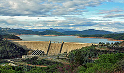
Points of interest in Shasta County include Shasta Lake, Lassen Peak, and the Sundial Bridge.
Shasta County was one of the original counties of California, created in 1850 at the time of statehood. Parts of the county's territory were given to Siskiyou County in 1852, and to Tehama County in 1856.
The county was named after Mount Shasta; the name "Shasta" is derived from the English equivalent for the name of an Indian tribe that once lived in the area. The name of the tribe was spelled in various ways until the present version was used when the county was established. Originally Mt. Shasta was within the county, but it is now part of Siskiyou County, to the north. Its 14,179-foot (4,322 m) peak is visible throughout most of Shasta County.
According to the U.S. Census Bureau, the county has a total area of 3,847 square miles (9,960 km2), of which 3,775 square miles (9,780 km2) is land and 72 square miles (190 km2) (1.9%) is water. Mountains line the county on the east, north and west. The Sacramento River flows out of the mountains to the north, through the center of the county, and toward the Sacramento Valley to the south.
...
Wikipedia


