Pisgah National Forest
| Pisgah National Forest | |
|---|---|
|
IUCN category VI (protected area with sustainable use of natural resources)
|
|

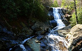
Upper Creek Falls near the community of Linville in Pisgah National Forest
|
|
| Location | North Carolina, United States |
| Nearest city | Asheville, NC |
| Coordinates | 35°21′36″N 82°47′35″W / 35.36°N 82.793°WCoordinates: 35°21′36″N 82°47′35″W / 35.36°N 82.793°W |
| Area | 512,758 acres (2,075.06 km2) |
| Established | October 17, 1916 |
| Governing body | U.S. Forest Service |
| Website | Pisgah National Forest |
Pisgah National Forest is a National Forest in the Appalachian Mountains of western North Carolina. It is administered by the United States Forest Service, part of the United States Department of Agriculture. The Pisgah National Forest is completely contained within the state of North Carolina. The forest is managed together with the other three North Carolina National Forests (Croatan, Nantahala, and Uwharrie) from common headquarters in Asheville, North Carolina. There are local ranger district offices located in Pisgah Forest, Mars Hill, and Nebo.
The Pisgah National Forest covers 512,758 acres (2075 km squ./ 801miles squ.) of mountainous terrain in the southern Appalachian Mountains, including parts of the Blue Ridge Mountains and Great Balsam Mountains. Elevations reach over 6,000 feet (1,800 m) and include some of the highest mountains in the eastern United States. Mount Mitchell, in Mount Mitchell State Park, is the highest mountain east of the Mississippi River and lies just outside the boundary of Pisgah National Forest. The forest also includes tracts surrounding the city of Asheville, the city of Brevard and land in the French Broad River Valley. Recreational opportunities include hiking and backpacking, among others. The land and its resources are also used for hunting, wildlife management, and timber harvesting, as well as the North Carolina Arboretum. The forest lies in parts of 12 counties in western North Carolina. In descending order they are Transylvania, McDowell, Haywood, Madison, Caldwell, Burke, Yancey, Buncombe, Avery, Mitchell, Henderson, and Watauga counties.
...
Wikipedia

