Nantahala National Forest
| Nantahala National Forest | |
|---|---|
|
IUCN category VI (protected area with sustainable use of natural resources)
|
|

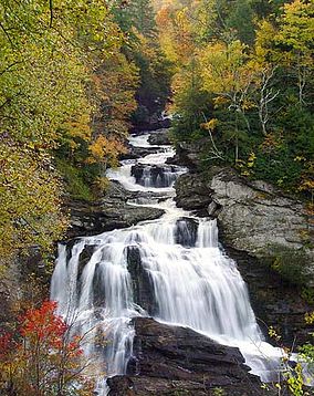
Cullasaja Falls, Nantahala National Forest, in Macon County, North Carolina
|
|
| Location | North Carolina, United States |
| Nearest city | Waynesville, NC |
| Coordinates | 35°14′02″N 83°33′33″W / 35.233842°N 83.559265°WCoordinates: 35°14′02″N 83°33′33″W / 35.233842°N 83.559265°W |
| Area | 531,270 acres (2,150.0 km2) |
| Established | February 6, 1907 |
| Governing body | U.S. Forest Service |
| Website | Nantahala National Forest |
The Nantahala /næntəˈheɪlə/ National Forest, established in 1920, is a national forest located in the American state of North Carolina. The word "Nantahala" is a Cherokee word meaning "Land of the Noonday Sun." The name is appropriate as, in some spots, the sun only reaches the floors of the deep gorges of the national forest when directly overhead at midday. The Spanish Conquistador Hernando de Soto explored the area in 1540, as did William Bartram in the 18th century. The Nantahala River flows through the Nantahala National Forest.
The Nantahala National Forest is administered by the United States Forest Service, part of the United States Department of Agriculture. The forest is managed together with the other three North Carolina National Forests (Croatan, Pisgah, and Uwharrie) from common headquarters in Asheville, North Carolina.
Nantahala National Forest is the largest of the four national forests in North Carolina, lying in the mountains and valleys of western North Carolina. The terrain varies in elevation from 5,800 feet (1,767.8 m) at Lone Bald in Jackson County, to 1,200 feet (365.8 m) in Cherokee County along the Hiwassee River below the Appalachian Dam. It is the home of many western NC waterfalls. The last part of the Mountain Waters Scenic Byway travels through this forest. The total area under management is 531,270 acres (830.11 sq mi; 2,149.97 km2). In descending order of land area it is located in parts of Macon, Graham, Cherokee, Jackson, Clay, and Swain counties.
...
Wikipedia

