Graham County, North Carolina
| Graham County, North Carolina | |
|---|---|

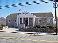
Graham County Courthouse in Robbinsville
|
|
 Location in the U.S. state of North Carolina |
|
 North Carolina's location in the U.S. |
|
| Founded | 1872 |
| Named for | William A. Graham |
| Seat | Robbinsville |
| Largest town | Robbinsville |
| Area | |
| • Total | 302 sq mi (782 km2) |
| • Land | 292 sq mi (756 km2) |
| • Water | 9.6 sq mi (25 km2), 3.2% |
| Population | |
| • (2010) | 8,861 |
| • Density | 30/sq mi (12/km²) |
| Congressional district | 11th |
| Time zone | Eastern: UTC-5/-4 |
| Website | www |
Graham County is a county located in the U.S. state of North Carolina. As of the 2010 census, the population was 8,861, making it the third-least populous county in North Carolina. Its county seat is Robbinsville. The county was formed January 30, 1872, from the northeastern part of Cherokee County. It was named for William A. Graham,United States Senator from North Carolina (1840–1843) and Governor of North Carolina (1845–1849).
According to the U.S. Census Bureau, the county has a total area of 302 square miles (780 km2), of which 292 square miles (760 km2) is land and 9.6 square miles (25 km2) (3.2%) is water. The terrain of the county is mountainous, with elevations ranging from 1,177 feet (359 m) to 5,560 feet (1,690 m). Two-thirds of the county is the Nantahala National Forest. The soil of the valleys is fertile.
Fontana Lake, an impoundment of the Little Tennessee River, forms most of the northern border of the county, with the Great Smoky Mountains National Park on the other side of the lake. Fontana Lake is formed by Fontana Dam, the tallest dam in the eastern U.S. The remainder of the northern boundary of Graham County is almost completely formed by another impoundment of the Little Tennessee River, downstream from Fontana Dam, created by Cheoah Dam. Fontana Dam and Cheoah Dam are both operated by the Tennessee Valley Authority.
...
Wikipedia
