Hiwassee River
| Hiwassee River | |
| River | |
|
Near the bridge of U.S. Highway 411 in Tennessee. Gee Knob and Chestnut Mountain are on the left.
|
|
| Country | United States |
|---|---|
| States | Georgia, North Carolina, Tennessee |
| Tributaries | |
| - left | Nottely River, Ocoee River |
| - right | Valley River |
| Source | North slope of Rocky Mountain in Towns County, Georgia |
| - elevation | 3,640 ft (1,109 m) |
| - coordinates | 34°48′4″N 83°44′4″W / 34.80111°N 83.73444°W |
| Mouth | Tennessee River at Hiwassee Island in Meigs County, Tennessee |
| - elevation | 682 ft (208 m) |
| - coordinates | 35°24′36″N 85°0′36″W / 35.41000°N 85.01000°WCoordinates: 35°24′36″N 85°0′36″W / 35.41000°N 85.01000°W |
| Length | 147 mi (237 km) |
| Basin | 2,700 sq mi (6,993 km2) |
| Discharge | for Apalachia Dam powerhouse vicinity, 53.2 miles (85.6 km) above the mouth |
| - average | 2,431 cu ft/s (69 m3/s) (mean for water years 1942-1979) |
| - max | 47,100 cu ft/s (1,334 m3/s) May 1973 |
| - min | 30 cu ft/s (0.8 m3/s) September 1955 |
|
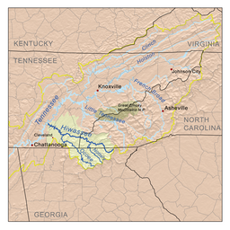
The Hiwassee drainage basin
|
|
The Hiwassee River has its headwaters on the north slope of Rocky Mountain in Towns County in northern Georgia and flows northward into North Carolina before turning westward into Tennessee, flowing into the Tennessee River a few miles west of State Route 58 in Meigs County, Tennessee. The river is 147 miles (237 km) long.
The river is dammed by the Tennessee Valley Authority (TVA) in four locations, all in western North Carolina. Chatuge Dam, Mission Dam, Hiwassee Dam, and Apalachia Dam. Water is diverted from the stream bed at Apalachia Dam and sent through a pipeline which is tunneled through the mountains for eight miles (13 km), then gravity-fed through the Apalachia Powerhouse to generate electricity. The stretch of the river that flows between Apalachia Dam and Apalachia Powerhouse features reduced flow and is shadowed by the John Muir Trail in Tennessee's Cherokee National Forest.
The 23-mile (37 km) stretch of river that flows from the North Carolina/Tennessee state line to U.S. Highway 411 near Delano is designated a State Scenic River (Class III Partially Developed River) and for recreational purposes is managed by the state Resource Management Division, in cooperation with TVA.
The river features Class I through Class III rapids, depending on water levels.
After exiting the mountains through a gorge, the Hiwassee flows under US-411 and broadens, meandering through rural Polk and Bradley counties. The river crosses under U.S. Route 11 at Calhoun and Charleston, Tennessee, where local industries such as Bowater Newsprint Mill and Arch/Olin Chemical use river water in their operations. At this point the river interfaces with the impoundment of Chickamauga Dam (located in Chattanooga, Tennessee), and many marshes and wetlands surround the main channel, providing areas for hunting and fishing. The Hiwassee passes under Interstate 75 on the border of McMinn and Bradley counties. The Hiwassee continues westward to pass under TN-58's historic, and narrow, bridge (this bridge has been replaced with a wide and modern bridge) on its way to the confluence with the Tennessee River. This area of the river is enjoyed by boaters, fishermen, and water skiers.
...
Wikipedia


