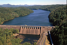
Apalachia Dam
| Apalachia Dam | |
|---|---|
 |
|
| Official name | Apalachia Dam |
| Location | Cherokee County, North Carolina, United States |
| Coordinates | 35°10′4″N 84°17′44″W / 35.16778°N 84.29556°WCoordinates: 35°10′4″N 84°17′44″W / 35.16778°N 84.29556°W |
| Construction began | July 17, 1941 |
| Opening date | February 14, 1943 |
| Operator(s) | Tennessee Valley Authority |
| Dam and spillways | |
| Impounds | Hiwassee River |
| Height | 150 ft (46 m) |
| Length | 1,308 ft (399 m) |
| Reservoir | |
| Creates | Apalachia Reservoir |
| Total capacity | 57,800 acre·ft (71,300 dam3) |
| Catchment area | 1,018 sq mi (2,640 km2) |
Apalachia Dam is a hydroelectric dam on the Hiwassee River in Cherokee County, in the U.S. state of North Carolina. The dam is the lowermost of three dams on the river owned and operated by the Tennessee Valley Authority, which built the dam in the early 1940s to provide emergency power for aluminum production during World War II. While the dam is in North Carolina, an 8.3-mile (13.4 km) underground conduit carries water from the dam's reservoir to the powerhouse located 12 miles (19 km) downstream across the state line in Polk County, Tennessee.
Apalachia Dam is named for the crossroads community of Old Apalachia, located near the dam site in North Carolina, and the community's L&N railroad stop, known simply as Apalachia, which was further downstream on the Tennessee side of the state line.
Apalachia Dam is located nearly 66 miles (106 km) upstream from the mouth of the Hiwassee River, which flows northwestward through Northern Georgia and Western North Carolina before emptying into Chickamauga Lake in East Tennessee. The dam is situated near the center of a scenic and relatively isolated valley sliced by the river as it winds its way through the southwestern fringe of the Blue Ridge Mountains. The Unicoi Mountains rise to the north of the dam, and the Nantahala National Forest surrounds the dam and its reservoir on all sides.
Apalachia Dam's powerhouse is located 12 miles (19 km) downstream from the dam at the base of a steep-walled gorge formed as the river flows between two mountain formations. The dam's 8.3-mile (13.4 km) conduit— all but 1,600 feet (490 m) of which is underground— passes behind the cliffs on the south side of the river.
...
Wikipedia
