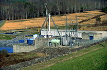
Chatuge Dam
| Chatuge Dam | |
|---|---|
 |
|
| Official name | Chatuge Dam |
| Location | Clay County, North Carolina, United States |
| Coordinates | 35°1′3″N 83°47′28″W / 35.01750°N 83.79111°WCoordinates: 35°1′3″N 83°47′28″W / 35.01750°N 83.79111°W |
| Construction began | July 17, 1941 |
| Opening date | February 12, 1942 |
| Operator(s) | Tennessee Valley Authority |
| Dam and spillways | |
| Impounds | Hiwassee River |
| Height | 144 ft (44 m) |
| Length | 2,850 ft (870 m) |
| Reservoir | |
| Creates | Chatuge Lake |
Chatuge Dam is a flood control and hydroelectric dam on the Hiwassee River in Clay County, in the U.S. state of North Carolina. The dam is the uppermost of three dams on the river owned and operated by the Tennessee Valley Authority, which built the dam in the early 1940s for flood storage and to provide flow regulation at Hiwassee Dam further downstream. The dam impounds the 7,000-acre (2,800 ha) Chatuge Lake, which straddles the North Carolina-Georgia state line. While originally built solely for flood storage, a generator installed at Chatuge in the 1950s gives the dam a small hydroelectric output.
Chatuge Dam is named for an 18th-century Cherokee village once situated near the dam site.
Chatuge Dam is located 121 miles (195 km) above the mouth of the Hiwassee River, just north of the North Carolina-Georgia state line. Chatuge Lake extends southward for 13 miles (21 km) along the Hiwassee and eastward for roughly 6 miles (9.7 km) along Shooting Creek, which once emptied into the Hiwassee immediately upstream from the dam site. The dam and the North Carolina section of the reservoir are surrounded by the Nantahala National Forest, and the Georgia section of the reservoir is surrounded by the Chattahoochee National Forest. Hayesville, North Carolina (north of the dam) and Hiawassee, Georgia (to the south) are the nearest communities of note.
Chatuge Dam is an earth-and-rock dam 144 feet (44 m) high and 2,850 feet (870 m) long, and has a generating capacity of 10,000 kilowatts. The dam's concrete overflow "ski-jump" spillway consists of 50 bays with a combined discharge of 11,500 cubic feet per second (330 m3/s). Chatuge Lake has a flood storage capacity of 62,619 acre feet (77,239,000 m3) and 132 miles (212 km) of shoreline.
Water passes Chatuge Dam via the dam's intake tower (connected to the dam by a footbridge), from which a steel conduit carries the water under the dam and empties it downstream.
...
Wikipedia
