Meigs County, Tennessee
| Meigs County, Tennessee | |
|---|---|

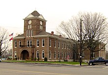
Meigs County Courthouse in Decatur
|
|
|
Location in the U.S. state of Tennessee |
|
 Tennessee's location in the U.S. |
|
| Founded | 1836 |
| Named for | Return J. Meigs |
| Seat | Decatur |
| Largest town | Decatur |
| Area | |
| • Total | 217 sq mi (562 km2) |
| • Land | 195 sq mi (505 km2) |
| • Water | 22 sq mi (57 km2), 10% |
| Population | |
| • (2010) | 11,753 |
| • Density | 60/sq mi (23/km²) |
| Congressional district | 4th |
| Time zone | Eastern: UTC-5/-4 |
Meigs County is a county located in the U.S. state of Tennessee. As of the 2010 census, the population was 11,753. Its county seat is Decatur.
Before 1819, the area that is now Meigs County was part of the Cherokee nation. However, white settlers established ferries across the Tennessee River from Rhea County as early as 1807. Colonel Return J. Meigs, who was to become the county's name source, operated a federal Indian agency across the river in Rhea County until 1817, when the agency moved to what is now Meigs County. In 1819, the Calhoun Treaty opened the land to settlement. Meigs County was formed in 1836 from parts of Rhea County.
The Cherokee Removal, or "Trail of Tears," crossed the Tennessee River at Blythe Ferry, in the southwestern part of the county.
Meigs County was one of the few East Tennessee counties to vote in favor of Tennessee's Ordinance of Secession in June 1861, at the outbreak of the Civil War. The county voted 481 to 267 in favor of the Ordinance, which severed the state's ties to the Union. The county would provide troops for both sides during the course of the war.
In 1985, the Meigs County Family and Community Education (“FCE”) Club began a large quilt to commemorate the early history of Meigs County as part of Tennessee's 1986 Homecoming celebrations. It includes images of fourteen sites representing the early history of Meigs County. The central quilt design, including a map to locate the sites represented, was made by the late Flossie Bennett, a longtime leader of the FCE. A committee of representatives from Ten Mile, Peakland, Concord, Goodfield, and Decatur, decided which sites would be included. Those chosen were the Elisha Sharp House (now the Sharp-Wasson-Worth House, c. 1825), the Stewart House (1830), R. H. Johnson's stable, Mount Zion church and Cemetery (1830), Zeigler's Mill (1850, previously called Gettys Mill), the Washington Ferry (1808), Pisah Church (1818), the old gymnasium (c. 1822), the old Meigs County Courthouse (1904), the old Volunteer Electric Cooperative BUilding (1935), the Ashley House (1885), and the Sam Eaves Store (c. 1861). The quilt also included Hereford cattle, since Meigs County is noted for its beef cattle. The quilt was awarded the “Best Original Design” at the McMinn County Living Heritage Museum's Quilt Show. Initially displayed at the Meigs-Decatur Public Library, the quilt now hangs in the Meigs County Historical Museum in Decatur.
...
Wikipedia
