Henderson County, North Carolina
| Henderson County, North Carolina | |
|---|---|
| County | |
| Henderson County | |

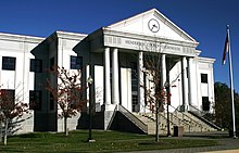
The current Henderson County Courthouse
|
|
 Location in the U.S. state of North Carolina |
|
 North Carolina's location in the U.S. |
|
| Founded | December 15, 1838 |
| Named for | Leonard Henderson |
| Seat | Hendersonville |
| Largest city | Hendersonville |
| Area | |
| • Total | 375 sq mi (971 km2) |
| • Land | 373 sq mi (966 km2) |
| • Water | 2.2 sq mi (6 km2), 0.6% |
| Population (est.) | |
| • (2013) | 109,540 |
| • Density | 286/sq mi (110/km²) |
| Congressional district | 11th |
| Time zone | Eastern: UTC-5/-4 |
| Website | www |
Henderson County is a county located in the U.S. state of North Carolina. As of the 2010 census, the population was 106,740. Its county seat is Hendersonville.
Henderson County is part of the Asheville, NC Metropolitan Statistical Area.
The county was formed in 1838 from the southern part of Buncombe County. It was named for Leonard Henderson, Chief Justice of the North Carolina Supreme Court from 1829 to 1833. There is no evidence Henderson ever passed through the area.
In 1855 parts of Henderson County and Rutherford County were combined to form Polk County, and in 1861 parts of Henderson County and Jackson County were combined to form Transylvania County.
Henderson County, which in 1861 encompassed present-day Transylvania County as well, contributed 1,296 soldiers to the Confederate States Army out of its approximately 10,000 population, as well as 130 Union troops. (Figures from Terrell T. Garren's "Mountain Myth: Unionism in Western North Carolina, published 2006).
Henderson County government was centered around Hendersonville in the 1905 county courthouse on Main Street, until this structure was replaced by the new Courthouse (c. 1995) on Grove Street in Hendersonville.
...
Wikipedia
