Brevard, North Carolina
| Brevard, North Carolina | |
|---|---|
| City | |

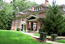
Ross Hall, Brevard College
|
|
 Location of Brevard, North Carolina |
|
| Coordinates: 35°14′30″N 82°43′43″W / 35.24167°N 82.72861°WCoordinates: 35°14′30″N 82°43′43″W / 35.24167°N 82.72861°W | |
| Country | United States |
| State | North Carolina |
| County | Transylvania |
| Government | |
| • Mayor | Jimmy Harris |
| Area | |
| • Total | 4.8 sq mi (12.5 km2) |
| • Land | 4.8 sq mi (12.4 km2) |
| • Water | 0.0 sq mi (0.0 km2) |
| Elevation | 2,231 ft (680 m) |
| Population (2000) | |
| • Total | 7,609 |
| • Density | 1,412.6/sq mi (545.4/km2) |
| Time zone | Eastern (EST) (UTC-5) |
| • Summer (DST) | EDT (UTC-4) |
| ZIP code | 28712 |
| Area code(s) | 828 |
| FIPS code | 37-07720 |
| GNIS feature ID | 1009587 |
| Website | www |
Brevard is a city in Transylvania County, North Carolina, United States, with a population of 7,609 as of the 2010 Census. It is the county seat of Transylvania County.
Brevard is located at the entrance to Pisgah National Forest and has become a noted tourism, retirement and cultural center in western North Carolina. A moderate climate, environmental beauty and cultural activities attract relocators to the area.
Brevard is also known for its white squirrels. There are several theories of how they came to live there, including an overturned carnival truck and an escaped pet breeding with native squirrels.
Brevard is also adjacent to DuPont State Forest, which is the only North Carolina State Forest designated as a recreational forest, and which attracted more than 650,000 visitors in 2015. A waterfall in the forest, Triple Falls, was used as a filming location for The Hunger Games.
Along with nearby Asheville and Hendersonville, Brevard forms the Asheville-Brevard, NC CSA combined statistical area.
According to the United States Census Bureau, the city has a total area of 5.12 square miles. Of that 0.21% is water.
The area's many waterfalls have earned it the nickname,"The Land of Waterfalls." Some notable examples include Looking Glass Falls, Connestee Falls and Batson Creek Falls, and Sliding Rock.
As of the census of 2010, there were 7,609 people, 3,253 households, and 1,711 families residing in the city. The population density was 1,486 people per square mile (545.0/km²). The racial makeup of the city was 83.3% White, 11.0% African American, 0.3% Native American, 1.0% Asian, 0.07%, 0.46% from other races, and 2.7% from two or more races. Hispanic or Latino of any race were 3.7% of the population.
...
Wikipedia
