Paraguana xeric scrub
| Paraguana xeric scrub (NT1313) | |
|---|---|

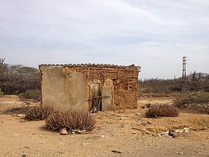
Abandoned wattle and daub house on the Paraguaná Peninsula
|
|
| Ecology | |
| Realm | Neotropical |
| Biome | Deserts and xeric shrublands |
| Geography | |
| Area | 16,058 km2 (6,200 sq mi) |
| Countries | Venezuela |
| Coordinates | 11°03′32″N 70°04′44″W / 11.059°N 70.079°WCoordinates: 11°03′32″N 70°04′44″W / 11.059°N 70.079°W |
| Climate type | BSh: arid, steppe, hot arid |
The Paraguana xeric scrub (NT1313) is an ecoregion in Venezuela to the north and east of Lake Maracaibo along the Caribbean coast. The region holds flora and fauna adapted to the very dry conditions of the coastal dunes and inland areas of bush, scrub, briars and cacti. There are several endangered species of animals and birds. Efforts at protecting the environment have been ineffective. Most of the original trees have been cut down, dunes are being destabilized by loss of vegetation, scrub is replaced by farmland and vegetation is destroyed by grazing goats.
The Paraguana xeric scrub is in the northwest of Venezuela. It has an area of 1,605,792 hectares (3,968,000 acres). It extends along the Caribbean coast to the east of the mouth of Lake Maracaibo and includes the Paraguaná Peninsula. A belt of the xeric scrub extends inland to the foothills of the Venezuelan Andes to the west of Barquisimeto.
Along the Caribbean coast there are stretches of Amazon-Orinoco-Southern Caribbean mangroves. To the east the ecoregion merges into the Lara-Falcón dry forests ecoregion, and to the west merges into the Maracaibo dry forests ecoregion. In the south it meets the northeastern section of the Venezuelan Andes montane forests. The southeastern extreme of the ecoregion connects to the La Costa xeric shrublands.
The ecosystem includes the valleys of the Lara–Falcón depression in the coastal plains north of the foothills of the Venezuelan Andes, and the Paraguaná Peninsula. In the Pliocene epoch the peninsula was an island Paraguana has four marine terraces at 6 metres (20 ft), 15–20 metres (49–66 ft), 40–50 metres (130–160 ft) and 80 metres (260 ft) surrounding the Cerro Santa Ana inselberg. The 830 metres (2,720 ft) Cerro Santa Ana is the highest point in the hills of the center of the former island. The long, narrow and low Médanos Isthmus that joins Paraguana to the mainland was formed about 3,000 years ago by tectonic uplift. A 32 kilometres (20 mi) long ledge of exposed beach rock protects the eastern shore from strong wave action.
...
Wikipedia
