Lake Maracaibo
| Lake Maracaibo | |
|---|---|

|
|

Map
|
|
| Coordinates | 09°48′57″N 71°33′24″W / 9.81583°N 71.55667°WCoordinates: 09°48′57″N 71°33′24″W / 9.81583°N 71.55667°W |
| Type | Coastal saltwater, bay |
| Primary inflows | Catatumbo River |
| Primary outflows | Gulf of Venezuela |
| Basin countries | Venezuela |
| Max. length | 99 miles (159 km) |
| Max. width | 67 miles (108 km) |
| Surface area | 13,210 km2 (5,100 sq mi) |
| Max. depth | 60 m (200 ft) |
| Water volume | 280 km3 (230,000,000 acre·ft) |
| Surface elevation | 0 m (0 ft) |
| Islands | 467 |
| Settlements | Maracaibo, Cabimas |
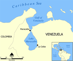
Lake Maracaibo (Spanish: Lago de Maracaibo) is a large brackish tidal bay (or tidal estuary) in Venezuela and an "inlet of the Caribbean Sea." It is sometimes considered a lake rather than a bay or lagoon. It is connected to the Gulf of Venezuela by Tablazo Strait which is 5.5 kilometres (3.4 mi) wide at the northern end. It is fed by numerous rivers, the largest being the Catatumbo. At 13,210 square kilometres (5,100 sq mi) it was once the largest lake in South America; the geological record shows that it has been a true lake in the past, and as such is one of the oldest lakes on Earth at 20–36 million years old.
Lake Maracaibo acts as a major shipping route to the ports of Maracaibo and Cabimas. The surrounding Maracaibo Basin contains large reserves of crude oil, making the lake a major profit center for Venezuela. It also holds almost a quarter of Venezuela's population. A dredged channel gives oceangoing vessels access to the bay. The 8.7-kilometre (5.4 mi) long General Rafael Urdaneta Bridge, which was completed in 1962 and spans the bay's outlet, is one of the longest bridges in the world.
The weather phenomenon known as the Catatumbo lightning at Lake Maracaibo regularly produces more lightning than any other place on the planet.
The first known settlements on the bay were those of the Guajiros, who still are present in large numbers, but were re-settled in the western boundary area with Colombia. The first European to discover the bay was Alonso de Ojeda on August 24, 1499, on a voyage with Amerigo Vespucci (the same explorer for whom the American continents were named).
...
Wikipedia
