Palauli
| Palauli | |
|---|---|
| District | |

Taga blowholes on the coast.
|
|
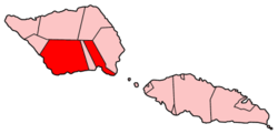
 Map of Samoa showing Palauli district |
|
| Country |
|
| Population (2001) | |
| • Total | 8,984 |
| Time zone | -11 |
Palauli is a district and village of Samoa, with a population (2001 Census) of 8,984. It consists of two sections on the southern side of Savai'i. The capital is Vailoa which is also referred to as Vailoa i Palauli (Vailoa in Palauli district).
Geological formations of lava tubes have created the Taga Blowholes on the coast of Taga village and attracts visitors and tourists.
In recent years, the inland village of Sili has refused the government of Samoa from building a hydro power plant on traditional land due to conservation and cultural concerns.
The paramount title of this district is Lilomaiava, which is conferred in Vailoa. As part of the selection process for the title-holder, Vailoa must consult with Safotu village in the Gagaifomauga political district. Safotu is the northern base of the Lilomaiava title in Savai'i. Lilomaiava carried the Malietoa title into the island of Upolu, a name given to Lilomaiava after defeating the Tongan Monarchy in a gaming challenge. Malietoa in the Tongan language means strength and courage.
Extensive pre-historic settlements have been surveyed and studied in the Palauli district where the Pulemelei Mound is situated.
Satellite photo of Palauli and Satupa'itea districts, southside of Savai'i island. (NASA photo).
View from Pulemelei Mound
Volcanic coastline.
Mu Pagoa Falls by the sea.
Coordinates: 13°42′S 172°28′W / 13.700°S 172.467°W
...
Wikipedia
