Safotu
| Safotu | |
|---|---|
| Village | |

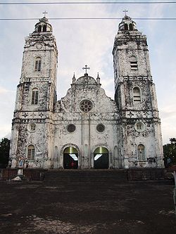
Historic Catholic church in Safotu, 2007
|
|
| Coordinates: 13°27′10″S 172°24′13″W / 13.45278°S 172.40361°WCoordinates: 13°27′10″S 172°24′13″W / 13.45278°S 172.40361°W | |
| Country |
|
| District | Gagaifomauga |
| Population (2006) | |
| • Total | 1,382 |
| Time zone | -11 |
Safotu is a village on the central north coast of Savai'i island in Samoa. Safotu is in the district Gagaifomauga. Traditionally, it attained the status of 'Pule,' customary political authority, and has been the main centre of the Gagaifomauga district.
Safotu is also associated with the chiefly matai Ao title of Lilomaiava.
The village is situated by the sea with a district hospital and school at the west end. The hospital sits upon a small rocky rise of black volcanic rock. The main island road passes through the village and there are several churches and local stores. A turnoff from the main road leads to the inland village settlement of Paia. Safotu is about 46 km from Salelologa and the ferry terminal. The popular tourist destination Manase village is the neighbouring village to the east. Heading west past the village is Samauga followed by Lefagaoali'i and Safune.
Safotu is situated on a coastal strip at the west end of a volcanic escarpment approximately 50 m high that runs down to the coast. The coastal strip extends inland rising steadily towards Mt Matavanu. Atuimo Point is a rocky headland forming one end of Safotu beach. The lagoon varies from 300m - 400m in width along the coast with small reef breaks off the shore.
There are small freshwater springs surfacing along the shore and some of these are contained as village pools at the western end of Safotu beach.
In pre-history, Safotu was a settlement for Tongans Talaaifeii was the name of one of the Tongan chiefs.
There are different stories about the origin of the name Safotu.
...
Wikipedia

