Nikolayevsk-on-Amur
| Nikolayevsk-on-Amur (English) Николаевск-на-Амуре (Russian) 庙街 (Chinese) |
|
|---|---|
| - Town - | |
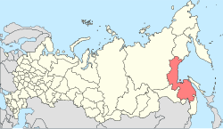
 Location of Khabarovsk Krai in Russia |
|
|
|
|
|
|
|
|
|
|
| Administrative status (as of September 2011) | |
| Country | Russia |
| Federal subject | Khabarovsk Krai |
| Administratively subordinated to | town of krai significance of Nikolayevsk-on-Amur |
| Administrative center of | town of krai significance of Nikolayevsk-on-Amur,Nikolayevsky District |
| Municipal status (as of October 2010) | |
| Municipal district | Nikolayevsky Municipal District |
| Urban settlement | Nikolayevsk-na-Amure Urban Settlement |
| Administrative center of | Nikolayevsky Municipal District, Nikolayevsk-na-Amure Urban Settlement |
| Head | Pyotr Volynsky |
| Statistics | |
| Population (2010 Census) | 22,752 inhabitants |
| Time zone | VLAT (UTC+10:00) |
| Founded | August 13, 1850 |
| Town status since | 1856 |
| Postal code(s) | 682460 |
| Dialing code(s) | +7 42135 |
| on | |
Nikolayevsk-on-Amur (Russian: Никола́евск-на-Аму́ре, Nikolayevsk-na-Amure; Chinese: 庙街; pinyin: Miaojie; Manchu: ᠮᡳᠶᠣᠣ
ᡤᠠᡧᠠᠨ; Möllendorff: miyoo gašan) is a town in Khabarovsk Krai, Russia located on the Amur River close to its liman in the Pacific Ocean. Population: 22,752 (2010 Census);28,492 (2002 Census);36,296 (1989 Census).
The town is situated on the left bank of the Amur River, 80 kilometers (50 mi) from where it flows into the Amur estuary, 977 kilometers (607 mi) north of Khabarovsk and 582 kilometers (362 mi) from the Komsomolsk-on-Amur railway station. It is the closest significant settlement to the Strait of Tartary separating the mainland from Sakhalin.
...
Wikipedia


