Niederzeuzheim
| Hadamar | ||
|---|---|---|

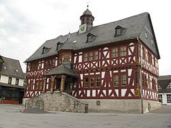
Hadamar town hall from 1639
|
||
|
||
| Coordinates: 50°27′N 8°3′E / 50.450°N 8.050°ECoordinates: 50°27′N 8°3′E / 50.450°N 8.050°E | ||
| Country | Germany | |
| State | Hesse | |
| Admin. region | Gießen | |
| District | Limburg-Weilburg | |
| Government | ||
| • Mayor | Hans Beresko | |
| Area | ||
| • Total | 40.99 km2 (15.83 sq mi) | |
| Elevation | 191 m (627 ft) | |
| Population (2015-12-31) | ||
| • Total | 12,426 | |
| • Density | 300/km2 (790/sq mi) | |
| Time zone | CET/CEST (UTC+1/+2) | |
| Postal codes | 65589 | |
| Dialling codes | 06433 | |
| Vehicle registration | LM | |
| Website | www.hadamar.de | |
Hadamar is a small town in Limburg-Weilburg district in Hessen, Germany.
Hadamar is known for its Clinic for Forensic Psychiatry/Centre for Social Psychiatry, lying at the edge of town, in whose outlying buildings is also found the Hadamar Memorial. This memorializes the murder of people with handicaps and mental illnesses during National Socialist times at the NS-Tötungsanstalt Hadamar.
Hadamar lies 7 km north of Limburg between Cologne and Frankfurt am Main on the southern edge of the Westerwald at elevations from 120 to 390 m above sea level.
Hadamar borders in the north on the communities of Dornburg, Elbtal and Waldbrunn, in the east on the community of Beselich, in the south on the town of Limburg and the community of Elz (all in Limburg-Weilburg) and in the west on the community of Hundsangen (in the Westerwaldkreis in Rhineland-Palatinate).
The town consists of eight formerly autonomous communities.
One of the oldest witnesses to the Hadamar region’s settlement is the cist (see also Megaliths) stemming from the Wartberg culture, and therefore some 5,000 years old, in Hadamar-Niederzeuzheim. A further grave was found in Oberzeuzheim, but it was taken apart and reassembled in the castle garden at Hachenburg (Westerwaldkreis).
...
Wikipedia


