New York State Route 300
| New York State Route 300 | ||||
|---|---|---|---|---|

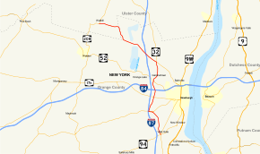
Map of Hudson Valley in southeastern New York with NY 300 highlighted in red
|
||||
| Route information | ||||
| Maintained by NYSDOT | ||||
| Length: | 14.67 mi (23.61 km) | |||
| Existed: | 1930 – present | |||
| Major junctions | ||||
| South end: |
|
|||
|
|
||||
| North end: |
|
|||
| Location | ||||
| Counties: | Orange, Ulster | |||
| Highway system | ||||
|
||||
New York State Route 300 (NY 300) is a state highway located west of the city of Newburgh in the Hudson Valley of New York in the United States. The southern terminus of the route is at a five-way intersection with NY 32 and NY 94 in the hamlet of Vails Gate. From there, it runs generally northwesterly through the towns of New Windsor, Newburgh, and Shawangunk, to a junction with NY 208 near the hamlet of Wallkill. NY 300's two major changes of direction are marked by slightly unorthodox intersections with other state highways.
NY 300 begins at a five-pronged junction with NY 32 and NY 94 in the hamlet of Vails Gate, also known as the Five Corners. The route heads north as Temple Hill Road, paralleling the New York State Thruway as it passes the New Windsor Cantonment State Historic Site, where George Washington dismissed the Continental Army in 1783. Following that, the highway begins to curve to the west ahead of an intersection with County Route 69 (CR 69), named Union Avenue. Here, NY 300 takes on the Union Avenue name just before intersecting and converging with NY 207 (Little Britain Road) adjacent to the James "Squire" Patton House—now the city of Newburgh's police K-9 unit training facility—at the southern tip of Lake Washington. At the next junction 0.4 miles (0.6 km) later, a signalized intersection just east of a Thruway overpass, NY 207 continues straight ahead to the west toward Goshen while NY 300 turns right and heads north.
...
Wikipedia

