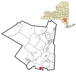
Wallkill, Ulster County, New York
| Wallkill | |
|---|---|
| CDP | |
 Location in Ulster County and the state of New York. |
|
| Coordinates: 41°36′N 74°10′W / 41.600°N 74.167°WCoordinates: 41°36′N 74°10′W / 41.600°N 74.167°W | |
| Country | United States |
| State | New York |
| County | Ulster |
| Area | |
| • Total | 3.1 sq mi (8 km2) |
| • Land | 3.1 sq mi (8 km2) |
| Population (2010) | |
| • Total | 2,288 |
| • Density | 740/sq mi (280/km2) |
| Time zone | Eastern (EST) (UTC-5) |
| • Summer (DST) | EDT (UTC-4) |
| ZIP codes | 12589 |
| Area code(s) | 845 |
| GNIS feature ID | 968702 |
Wallkill is a hamlet (and census-designated place), generally identified as coterminous with ZIP code 12589, telephone exchange 895 in the 845 area code and most of the Wallkill Central School District located mostly in the eastern half of the Town of Shawangunk, Ulster County, New York but partly spilling over into adjacent regions of the Orange County towns of Newburgh and Montgomery. The population was 2,288 at the 2010 census.
The community is in the Town of Shawangunk. Residents affectionately refer to the town by its unofficial nickname "The Kill". The Wallkill Correctional Facility and Shawangunk Correctional Facility are located in Wallkill. The hamlet's attractions include the Walden–Wallkill Rail Trail, the Original Borden Farm (namesake for the area's middle school), the Wallkill River, the Magnanini Winery, and for its proximity to the Shawangunk Mountains.
Before European settlement, this area was populated by the Munsee branch of the Lenape (Delaware) people, who occupied the upper Delaware Valley, the adjacent Catskill foothills, and most of what is now the state of New York south of the Catskills, as well as northern New Jersey (Kraft 2001). The Waronawanka (Waranawankong), known to history as the Esopus Indians, were the Munsee tribe present in the region of the Shawangunk Grasslands Refuge. They inhabited the Rondout-Wallkill Valleys/Shawangunk Mountain region southward to their boundary with the Murderer’s Kill Indians (Moodna Creek, near Cornwall) and southwestward along the Shawangunks to their border with the Minisink tribe, near where present Interstate 84 crosses the ridge in western Orange County (Fried 2005).
...
Wikipedia
