New York State Route 299
| New York State Route 299 | ||||
|---|---|---|---|---|

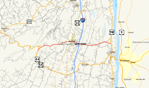
Map of Ulster County in eastern New York with NY 299 highlighted in red
|
||||
| Route information | ||||
| Maintained by NYSDOT, Ulster County and the village of New Paltz | ||||
| Length: | 12.39 mi (19.94 km) | |||
| Existed: | 1930 – present | |||
| Major junctions | ||||
| West end: |
|
|||
|
|
||||
| East end: |
|
|||
| Location | ||||
| Counties: | Ulster | |||
| Highway system | ||||
|
||||
New York State Route 299 (NY 299) is a short but important state route entirely within Ulster County, New York, in the United States. Centered on its interchange with the New York State Thruway outside New Paltz, it provides access from that road to the popular recreational attractions of the Shawangunk Ridge to the west and Poughkeepsie to the east. Only the eastern section is a state highway; from Shawangunk to New Paltz, it is owned and maintained by Ulster County.
NY 299 begins at an intersection with the concurrent US 44 and NY 55 just south of Lake Minnewaska in the town of Gardiner. NY 299 winds northeast through the deep woods of Gardiner, paralleling US 44 and NY 55 as it climbs through the Catskill Mountains. Passing well to the south of the hairpin turn on US 44 and NY 55, NY 299 bends eastward under control of Ulster County, with the County Route 8 (CR 8) designation. Near Hasbrouck Road, the dense woods recede and NY 299 crosses east through fields through Gardiner. Soon crossing into the town of New Paltz, NY 299 runs along the flood plain of the Wallkill River.
...
Wikipedia

