New River (Kanawha River)
| New River | |
|
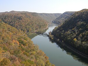
The New River within the New River Gorge as viewed from Hawks Nest State Park in West Virginia
|
|
| Country | United States |
|---|---|
| States | North Carolina, Virginia, West Virginia |
| Counties | Ashe NC, Alleghany NC, Watauga NC, Grayson VA, Carroll VA, Wythe VA, Pulaski VA, Montgomery VA, Giles VA, Mercer WV, Summers WV, Raleigh WV, Fayette WV |
| Tributaries | |
| - left | Bluestone River, East River |
| - right | Little River, Indian Creek, Greenbrier River |
| Source | South Fork New River |
| - location | Boone, NC |
| - elevation | 3,104 ft (946 m) |
| - coordinates | 36°12′16″N 81°38′59″W / 36.20444°N 81.64972°W |
| Secondary source | North Fork New River |
| - location | Elk Knob, Watauga County, NC |
| - elevation | 4,446 ft (1,355 m) |
| - coordinates | 36°19′59″N 81°41′04″W / 36.33306°N 81.68444°W |
| Source confluence | |
| - location | Ashe County, NC |
| - elevation | 2,546 ft (776 m) |
| - coordinates | 36°32′45″N 81°21′09″W / 36.54583°N 81.35250°W |
| Mouth | Kanawha River |
| - location | Gauley Bridge, WV |
| - elevation | 653 ft (199 m) |
| - coordinates | 38°09′42″N 81°11′47″W / 38.16167°N 81.19639°WCoordinates: 38°09′42″N 81°11′47″W / 38.16167°N 81.19639°W |
| Length | 320 mi (515 km) |
| Discharge | for Thurmond, WV, max and min at Glen Lyn, VA |
| - average | 8,730 cu ft/s (247 m3/s) |
| - max | 226,000 cu ft/s (6,400 m3/s) |
| - min | 538 cu ft/s (15 m3/s) |
|
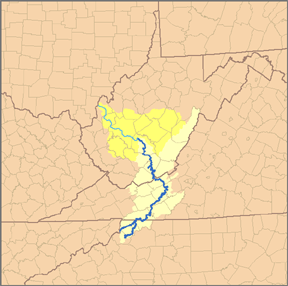
Map of the Kanawha River watershed, with the New River and its watershed highlighted.
|
|
The New River, part of the Ohio River watershed, is about 360 mi (515 km) long. The river flows through the U.S. states of North Carolina, Virginia, and West Virginia before joining with the Gauley River to form the Kanawha River at the town of Gauley Bridge, WV.
Much of the river's course through West Virginia is designated as the New River Gorge National River, and the New River is one of the nation's American Heritage Rivers. In 1975, North Carolina designated a 26.5-mile (42.6 km) segment of the river as "New River State Scenic River", by including it in the state's Natural and Scenic Rivers System. The segment was added to the National Wild and Scenic Rivers System the following year.
The origins of the name are unclear. Possibilities include being a new river that wasn't on the Fry-Jefferson map of Virginia, an Indian name meaning "new waters", or the surname of an early settler. Despite its name, the New River is one of the five oldest rivers in the world geologically.
This ancient river begins in the mountains of North Carolina near the Tennessee state line, flows generally northeastward across the Blue Ridge Mountains, Great Appalachian Valley, Ridge and Valley Province, and the Allegheny Front in western North Carolina and Virginia, before turning and following a more northwestward course into West Virginia, where it then cuts through the Appalachian Plateau (in the New River Gorge) to meet the Gauley River and become the Kanawha River in south-central West Virginia. The Kanawha then flows into the Ohio River at Point Pleasant, WV. Much of the river's course is lined with steep cliffs and rock outcrops, particularly in its gorge in West Virginia.
...
Wikipedia


