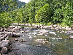
Bluestone River
| Bluestone River | |
|
Bluestone River in Pipestem Resort State Park
|
|
| Country | United States |
|---|---|
| States | Virginia, West Virginia |
| Counties | Tazewell VA, Mercer WV, Summers WV |
| Tributaries | |
| - left | Little Bluestone River |
| - right | Blacklick Creek (West Virginia) |
| Source | East River Mountain |
| - location | Tazewell County, Virginia |
| - elevation | 3,589 ft (1,094 m) |
| - coordinates | 37°10′19″N 81°24′58″W / 37.17194°N 81.41611°W |
| Mouth | New River in Bluestone Lake |
| - location | Summers County, West Virginia |
| - elevation | 1,424 ft (434 m) |
| - coordinates | 37°36′44″N 80°54′52″W / 37.61222°N 80.91444°WCoordinates: 37°36′44″N 80°54′52″W / 37.61222°N 80.91444°W |
| Length | 77 mi (124 km) |
| Discharge | for Pipestem, West Virginia |
| - average | 470 cu ft/s (13 m3/s) |
| - max | 19,300 cu ft/s (547 m3/s) peak (April 5, 1977) |
| - min | 7 cu ft/s (0 m3/s) daily mean (September 22, 1955) |
The Bluestone River is a tributary of the New River, 77 mi (124 km) long, in southwestern Virginia and southern West Virginia in the United States. Via the New, Kanawha and Ohio Rivers, it is part of the watershed of the Mississippi River. An 11 mi (18 km) portion of its lower course is designated as the Bluestone National Scenic River.
The Bluestone rises on East River Mountain in Tazewell County, Virginia and flows generally northeastwardly through Mercer and Summers Counties in West Virginia, passing the towns of Bluefield in Virginia and Bramwell and Montcalm in West Virginia. It joins the New River about 4 mi (6.4 km) south of Hinton as part of Bluestone Lake, which is formed by a U.S. Army Corps of Engineers dam on the New. The Bluestone's National Scenic River segment is located mostly in Summers County, as is Pipestem Resort State Park, which lies along a gorge formed by the river.
...
Wikipedia

