Montcalm, West Virginia
| Montcalm, West Virginia | |
|---|---|
| Census-designated place (CDP) | |
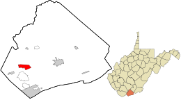
 Location in Mercer County and the state of West Virginia. |
|
| Coordinates: 37°21′16″N 81°15′3″W / 37.35444°N 81.25083°WCoordinates: 37°21′16″N 81°15′3″W / 37.35444°N 81.25083°W | |
| Country | United States |
| State | West Virginia |
| County | Mercer |
| Area | |
| • Total | 2.7 sq mi (7.1 km2) |
| • Land | 2.7 sq mi (7.1 km2) |
| • Water | 0.0 sq mi (0.0 km2) |
| Elevation | 2,218 ft (676 m) |
| Population (2010) | |
| • Total | 726 |
| • Density | 270/sq mi (100/km2) |
| Time zone | Eastern (EST) (UTC-5) |
| • Summer (DST) | EDT (UTC-4) |
| ZIP code | 24737 |
| Area code(s) | 304 |
| FIPS code | 54-55372 |
| GNIS feature ID | 1552173 |
Montcalm is a census-designated place (CDP) in Mercer County, West Virginia, United States. The population was 726 at the 2010 census. It is part of the Bluefield, WV-VA micropolitan area which has a population of 107,342.
The first record of continuous European settlement of the Montcalm area is the 1840 census of Mercer County in what was then the state of Virginia. A 700-acre farm, located where Crane Creek joins the Bluestone, was the property of George Bailey. He, his wife, and six children lived on the farm that included a farmhouse, likely located on the lower slopes of Tabernacle Mountain, an orchard and in what would be today’s Main Street, and a field of timothy grass. About one hundred acres of corn field could be found at the top of a mountain on the “the opposite side of the river” (either Methodist Church Hill or Browning Lambert Mountain). The farm also featured a small dam on the Crane Creek that powered a corn grist mill, the only one in the area and the farm’s most valuable property.
The Bailey family occupied this farm until 1852 when, in preparation for a move to the West, they sold their considerable estate and all of what would one day be the village of Montcalm for $1,500 to Robert Williams, a recently arrived retired sailor from the British Navy.
Williams wrote and published his experiences in Mercer County and in the events that led up to the Civil War in Kansas in a memoir published in 1908 titled With the Border Ruffians, which is the earliest narrative of life in Montcalm’s Bluestone Valley.
Williams wrote about meeting the leaders of the early Mercer County communities, a court day in Princeton, a church camp meeting in what would one day be Glenwood Park, hunting in the hills around the Bluestone, community dances and several threats to his life while homesteading on the former Bailey Farm.
After several legal disputes in which he was largely not at fault, Williams sold the farm for $2,000 to the Herndon family, a slave-holding clan who owned a neighboring farm. According to West Virginia historian Kyle McCormick, descendants of the family lived in Montcalm a century later.
...
Wikipedia
