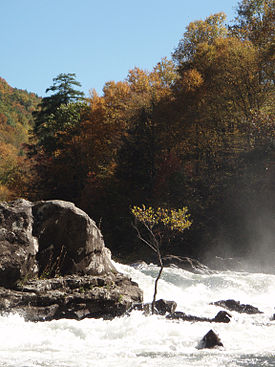
Gauley River
| Gauley River | |
| River | |
|
Sweet's Falls on the Gauley River
|
|
| Country | United States |
|---|---|
| State | West Virginia |
| Counties | Randolph, Webster, Nicholas, Fayette |
| Tributaries | |
| - left | Williams River, Cranberry River, Meadow River |
| Source | North Fork Gauley River |
| - location | Gauley Mountain, Pocahontas County, WV |
| - elevation | 4,000 ft (1,219 m) |
| - coordinates | 38°25′42″N 80°10′22″W / 38.42833°N 80.17278°W |
| Secondary source | South Fork Gauley River |
| - location | Pocahontas County, WV |
| - elevation | 3,937 ft (1,200 m) |
| - coordinates | 38°22′43″N 80°12′52″W / 38.37861°N 80.21444°W |
| Additional source | Middle Fork Gauley River |
| - location | Pocahontas County, WV |
| - elevation | 3,844 ft (1,172 m) |
| - coordinates | 38°23′21″N 80°11′29″W / 38.38917°N 80.19139°W |
| Source confluence | Three Forks of Gauley |
| - location | Webster County, WV |
| - elevation | 2,917 ft (889 m) |
| - coordinates | 38°24′33″N 80°14′17″W / 38.40917°N 80.23806°W |
| Mouth | Kanawha River |
| - location | Gauley Bridge, WV |
| - elevation | 660 ft (201 m) |
| - coordinates | 38°09′42″N 81°11′47″W / 38.16167°N 81.19639°WCoordinates: 38°09′42″N 81°11′47″W / 38.16167°N 81.19639°W |
| Discharge | for Belva, WV |
| - average | 2,680 cu ft/s (76 m3/s) |
| - max | 12,900 cu ft/s (365 m3/s) (1987) |
| - min | 341 cu ft/s (10 m3/s) (1976) |
The Gauley River is a 105-mile-long (169 km) river in West Virginia. It merges with the New River to form the Kanawha River, a tributary of the Ohio River. It is one of the most popular advanced whitewater runs in the Eastern United States and is the chief feature of the Gauley River National Recreation Area.
The Gauley rises in the Monongahela National Forest on Gauley Mountain in Pocahontas County as three streams, the North, Middle, and South Forks, each of which flows across the southern extremity of Randolph County; they converge in Webster County. The river then flows generally west-southwestwardly through Webster, Nicholas and Fayette counties, past the towns of Camden-on-Gauley and Summersville, to the town of Gauley Bridge, where it joins the New River to form the Kanawha River. Via the Kanawha and Ohio rivers, it is part of the Mississippi River watershed.
The Gauley's largest tributaries all flow into the main river from the east (flowing in a westerly direction) and are described as follows:
In Nicholas County, the Gauley is impounded by the Summersville Dam, a U.S. Army Corps of Engineers dam, to form Summersville Lake. The Gauley River National Recreation Area is downstream of the dam.
...
Wikipedia

