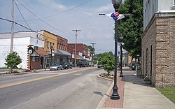
Summersville, West Virginia
| Summersville, West Virginia | |
|---|---|
| City | |

|
|
 Location of Summersville, West Virginia |
|
| Coordinates: 38°17′0″N 80°50′39″W / 38.28333°N 80.84417°WCoordinates: 38°17′0″N 80°50′39″W / 38.28333°N 80.84417°W | |
| Country | United States |
| State | West Virginia |
| County | Nicholas |
| Founded | 1824 |
| Area | |
| • Total | 4.26 sq mi (11.03 km2) |
| • Land | 4.22 sq mi (10.93 km2) |
| • Water | 0.04 sq mi (0.10 km2) |
| Elevation | 1,880 ft (573 m) |
| Population (2010) | |
| • Total | 3,572 |
| • Estimate (2012) | 3,570 |
| • Density | 846.4/sq mi (326.8/km2) |
| Time zone | Eastern (EST) (UTC-5) |
| • Summer (DST) | EDT (UTC-4) |
| ZIP code | 26651 |
| Area code(s) | 304, 681 |
| FIPS code | 54-77980 |
| GNIS feature ID | 1547739 |
Summersville is a city in Nicholas County, West Virginia, USA. The population was 3,572 at the 2010 census. It is the county seat of Nicholas County.
Summersville was laid out in 1824. The city was named for Lewis Summers, a local judge.
Summersville is home to the annual Potato Festival.
Summersville is located at 38°17′0″N 80°50′39″W / 38.28333°N 80.84417°W (38.283342, -80.844207). It is located just north of the Gauley River which is famous for its challenging whitewater. The river is impounded by a large dam which creates Summersville Lake, creating flatwater recreation as well.
According to the United States Census Bureau, the town has a total area of 4.26 square miles (11.03 km2), of which, 4.22 square miles (10.93 km2) is land and 0.04 square miles (0.10 km2) is water.
The climate in this area has mild differences between highs and lows, and there is adequate rainfall year round. According to the Köppen Climate Classification system, Summersville has a marine west coast climate, abbreviated "Cfb" on climate maps.
The median income for a household in the town was $29,783, and the median income for a family was $43,314. Males had a median income of $33,633 versus $22,348 for females. The per capita income for the town was $23,217. About 6.9% of families and 12.7% of the population were below the poverty line, including 8.1% of those under age 18 and 11.2% of those age 65 or over.
...
Wikipedia
