Monongahela National Forest
| Monongahela National Forest | |
| U.S. National Forest | |
|
View from the slopes of Back Allegheny Mountain looking east. Visible are Allegheny Mountain (middle distance) and Shenandoah Mountain (far distance). The latter is in the George Washington National Forest of Virginia
|
|
| Name origin: Monongahela River, in whose watershed much of the original forest was located | |
| Country | United States |
|---|---|
| State | West Virginia |
| Counties | Grant, Greenbrier, Nicholas, Pendleton, Pocahontas, Preston, Randolph, Tucker, Webster |
| Ranger Districts | Cheat-Potomac, Greenbrier, Marlinton-White Sulphur Springs, Gauley |
| Coordinates | 38°55′45″N 79°50′52″W / 38.92917°N 79.84778°WCoordinates: 38°55′45″N 79°50′52″W / 38.92917°N 79.84778°W |
| Highest point | Spruce Knob |
| - location | Pendleton County, WV |
| - elevation | 4,863 ft (1,482.2 m) |
| - coordinates | 38°41′59″N 79°31′58″W / 38.69972°N 79.53278°W |
| Lowest point | South Branch Potomac River |
| - location | west of Petersburg, WV |
| - elevation | 968 ft (295.0 m) |
| - coordinates | 39°00′05″N 79°09′46″W / 39.00139°N 79.16278°W |
| Area | 921,150 acres (372,776 ha) |
| - Proclamation Boundary | 1,706,898 acres (690,757 ha) |
| Established | April 28, 1920 |
| - Monongahela Purchase | 1915 |
| Owner | US Forest Service |
| IUCN category | VI - Managed Resource Protected Area |
| Headquarters | Elkins, West Virginia |
|
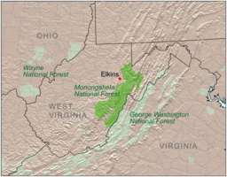
Location of Monongahela National Forest
|
|
| Website: Monongahela National Forest | |
The Monongahela National Forest is a national forest located in the Allegheny Mountains of eastern West Virginia, USA. It protects over 921,000 acres (3,727 km2; 1,439 sq mi) of federally owned land within a 1,700,000 acres (6,880 km2; 2,656 sq mi) proclamation boundary that includes much of the Potomac Highlands Region and portions of 10 counties.
The MNF includes some major landform features such as the Allegheny Front and the western portion of the Ridge-and-valley Appalachians. Within the forest are most of the highest mountain peaks in the state, including the highest, Spruce Knob (4,863 ft), also the highest point in the Alleghenies. Approximately 75 tree species are found in the forest. Almost all of the trees are a second growth forest, grown back after the land was heavily cutover around the start of the 20th century. Species for which the forest is important include red spruce (Picea rubens), balsam fir (Abies balsamea), and mountain ash (Sorbus americana).
The MNF includes eight U.S. Wilderness Areas and several special-use areas, notably the Spruce Knob-Seneca Rocks National Recreation Area.
The forest is administered from the main headquarters in Elkins, West Virginia, and four ranger districts. The forest has approximately 105 permanent employees, with this force augmented by senior citizens, temporary employees, and volunteers.
Monongahela National Forest is currently divided into four ranger districts. The Cheat-Potomac and Marlinton-White Sulphur Springs were formed by combining their namesake districts; in the merged districts, the offices for both original districts were retained.
...
Wikipedia


