Nayagarh State
| Nayagarh State ନୟାଗଡ଼ / नयागढ़ |
|||||
| Princely State of British India | |||||
|
|||||
|
Flag |
|||||
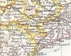
| Nayagarh State in the Imperial Gazetteer of India | |||||
| History | |||||
| • | Established | c. 1500 | |||
| • | Accession to the Union of India | 1948 | |||
| Area | |||||
| • | 1931 | 1,528 km2(590 sq mi) | |||
| Population | |||||
| • | 1931 | 142,406 | |||
| Density | 93.2 /km2 (241.4 /sq mi) | ||||
Flag
Nayagarh State (Odia: ନୟାଗଡ଼; Hindi: नयागढ़) was one of the princely states of India during the period of the British Raj. It was located in present-day Nayagarh district, Odisha.
The state was bounded in the north by Khandpara State and Puri District. The capital was at Nayagarh. The southern part of the state was forested and mountainous and was inhabited mainly by Khonds.
Nayagarh was founded before 1550 by Raja Surya Mani, a scion of the Rewa Royal Family. Khandpara State was initially part of Nayagarh State, but became a separate kingdom in 1599. The rulers were Rajputs of the Baghela or Vaghela dynasty. The last Raja of Nayagarh signed the instrument of accession to the Indian Union on 1 January 1948.
The story of the foundation of Nayagarh State is an important chapter in the political history of Odisha. Surya Mani of the Baghela dynasty came to Puri on a pilgrimage from Rewa of Madhya Pradesh and established his kingdom at Nayagarh. On the way to Puri, Both Surya Mani and his brother Chandramani rested at Gunanati for the night. The area was full of tigers and at night one of them attacked him. Both brothers fought the tiger and killed it. The local people praised the brave brothers and elected Surya Mani as their leader. Surya Mani gradually built his fort at Gunanati and married a Mali girl.
...
Wikipedia


