Narew
| Narew | |
| Нараў | |
| River | |
|
Braided channels of the Narew at Strękowa Góra
|
|
| Countries | Poland, Belarus |
|---|---|
| Voivodeships / Voblasts | Hrodna, Podlaskie, Mazovian |
| Source | |
| - location | north-eastern part of the Bialowieza Forest near Dzikie Bagno, Belarus |
| - elevation | 159 m (522 ft) |
| - coordinates | 52°52′24.68″N 24°13′8.87″E / 52.8735222°N 24.2191306°E |
| Mouth | |
| - location | Modlin (Nowy Dwór Mazowiecki), Poland |
| - elevation | 70.7 m (232 ft) |
| - coordinates | 52°26′N 20°41′E / 52.433°N 20.683°ECoordinates: 52°26′N 20°41′E / 52.433°N 20.683°E |
| Length | 484 km (301 mi) |
| Basin | 28,000 km2 (10,811 sq mi) |
| Discharge | for Modlin (Nowy Dwór Mazowiecki) |
| - average | 328 m3/s (11,583 cu ft/s) |
| Discharge elsewhere (average) | |
| - entering Pułtusk | 146 m3/s (5,156 cu ft/s) |
|
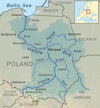
Narew River as part of the Vistula watershed
|
|
The Narew River ([ˈnarɛf]; Belarusian: Нараў Naraŭ, Ukrainian: Нарва Narva), in western Belarus and north-eastern Poland, is a right tributary of the Vistula river. The Narew is one of Europe's few braided rivers, the term relating to the twisted channels resembling braided hair.
The name of the river comes from a Proto-Indo-European root *nr primarily associated with water (compare Narva, Neretva, Neris, Ner and Nur).
The portion of the river between Zegrze Reservoir and the Vistula is sometimes called Bugonarew, Narwio-Bug, Narwo-Bug, Bugo-Narew, Narwiobug or Narwobug. At the confluence near Zegrze the Bug is longer than Narew, however, the Narew's discharge is much higher. Because of that the river was variously referred to as either Narew, Bug, Bugo-Narew, Bugonarew, Narwiobug or Narwobug.
Until after World War II rivers were commonly classified by their length. As at the confluence near Zegrze Bug is longer than Narew, the Bugonarew was often considered part of Bug river and Narew was thought of as its tributary. However, at the same time Narew's discharge is much higher at their meeting point.
...
Wikipedia


