Neretva
| Neretva | |
|---|---|

|
|

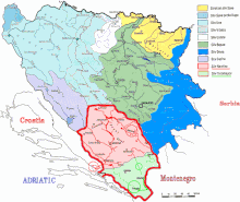
Neretva watershed highlighted in red
|
|
| Etymology | of Illyrian origin, from Indo-European base *ner-, *nor- "to dive, dip, immerse" |
| Countries | Bosnia and Herzegovina, Croatia |
| Region | Ulog, Glavatičevo, Konjic, Jablanica, Mostar, Počitelj, Čapljina, Metković, Opuzen, Ploče |
| Basin features | |
| Main source |
Lebršnik and Zelengora Mountains, Dinaric Alps, Bosnia and Herzegovina 1,227 m (4,026 ft) |
| River mouth |
Adriatic Sea near Ploče, Croatia 0 m (0 ft) |
| Basin size | 10,380 km2 (4,010 sq mi) |
| Tributaries | |
| Physical characteristics | |
| Length | 230 km (140 mi) |
| Discharge |
|
The Neretva (pronounced [nɛ̌rɛtʋa]), also known as the Narenta, is the largest river of the eastern part of the Adriatic basin. Four HE power-plants with large dams (higher than 15 metres) provide flood protection, power and water storage. It is still recognized for its natural beauty and diversity of its landscape.
Freshwater ecosystems have suffered from an increasing population and the associated development pressures. One of the most valuable natural resources of Bosnia and Herzegovina and Croatia is its freshwater resource, contained by an abundant wellspring and clear rivers. Situated between the major regional rivers (Drina river on the east, Una river on the west and the Sava river) the Neretva basin contains the most significant source of drinking water.
The Neretva is notable among rivers of the Dinaric Alps region, especially regarding its diverse ecosystems and habitats, flora and fauna, cultural and historic heritage.
The Neretva flows through Bosnia and Herzegovina and Croatia and is the largest karst river in the Dinaric Alps in the eastern part of the Adriatic basin/watershed. Its total length is 230 kilometres (143 miles), of which 208 kilometres (129 miles) are in Bosnia and Herzegovina, while the final 22 kilometres (14 miles) are in the Dubrovnik-Neretva County of Croatia.
...
Wikipedia
